Object Extents
Part of creating many objects in Leapfrog Geo is defining the basic rectangular boundary that defines the object’s extents. There are generally two options for defining an object’s extents:
- The first option is to define extents that are independent of other objects in the project. You can do this by entering coordinates or adjusting controls in the scene to set the size and shape of the extents. The new object’s extents are fixed to the specified size. This is a good choice if, for example, you are building a geological model from a map and wish to define the model extents based on information on the map.
- The second option is to define extents based on other objects in the project. This is done by selecting the other object from the Enclose Object list that appears in many Leapfrog Geo screens.
For both methods, the new object’s extents are fixed to the selected size. Using the Enclose Object list does not link the two objects, it is simply using the X-Y-Z coordinates of the original object as the basis for the new extents.
For example, here, a geological model’s extents could be defined using the lithology segments used as the base lithology:

When creating some objects, you have the option of sharing extents with another object. This is the case with editable meshes (![]() ), where you can choose whether the mesh has its own extents or shares extents with other objects in the project. Shared extents are updated when the original object’s extents are updated.
), where you can choose whether the mesh has its own extents or shares extents with other objects in the project. Shared extents are updated when the original object’s extents are updated.
If you are unsure about relationships between objects, expand them in the project tree to view more information. Here, two meshes have been defined from the same set of points:
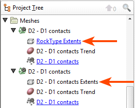
The first mesh shares its extents with another object in the project, which is indicated by the hyperlink. The second mesh has no hyperlink; it has its own extents that are not updated by other objects in the project.
Geological models and interpolants are created with a basic set of rectangular extents that can then be refined by adding extents created from other data in the project. Creating extents is a useful way of restricting modelling to a particular area of interest. For example, modelling can be restricted to a known distance from drillhole data by applying a distance function as a lateral extent. See Modifying a Geological Model’s Boundary for more information.