ModFlow Evaluations
This feature is only available as part of the Hydrogeology module. See Flow Modelling for more information.
When a ModFlow model is exported, the evaluated geological model is used to assign lithologies to the cells in the grid. If the grid has not been evaluated against a geological model, you must do so before you can edit the hydrological properties and before you can export the grid.
To evaluate a ModFlow model, expand the model in the project tree, then right-click on the grid object (![]() ) and select Evaluations. Although you can evaluate an interpolant or distance function, they cannot be exported with the grid and are simply used for displaying the grid in Leapfrog Geo.
) and select Evaluations. Although you can evaluate an interpolant or distance function, they cannot be exported with the grid and are simply used for displaying the grid in Leapfrog Geo.
A window will appear listing all objects in the project that can be used for an evaluation. Once you have selected one or more objects, click OK. You will then be able to select the evaluations from the view list, as described in Evaluations.
Assigning an Evaluation for Export
For ModFlow models created in Leapfrog Geo, the evaluation used when creating the model will automatically be assigned as the evaluation for export. A hydrological properties table (![]() ) will appear in the project tree as part of the model.
) will appear in the project tree as part of the model.
If the model was imported into Leapfrog Geo or created without being evaluated against a geological model, you will need to manually set the evaluation for export. To do this:
- Evaluate the grid against one or more geological models, as described above.
- Right-click on the model (
 or
or  ) in the project tree and select Set Evaluation for Export. The Select Evaluation window will appear showing all geological models evaluated on the grid. Select the required evaluation and click OK.
A hydrological properties table will be added to the model in the project tree. Edit hydrological properties by double-clicking on the table. See ModFlow Hydrological Properties.
Combined Evaluations
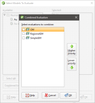
You can combine geological models and set the priority used for evaluation. This is useful when you have geological models available that describe different parts of the area of interest or if you have a refined geological model for part of the model. To combine geological models for evaluation, select the required models in the Select Models To Evaluate window, then click on the Combined Evaluation button.
In this example, there are three geological models selected:
The GM and GM from contacts models describe similar areas, but GM has more detail. The GM larger model describes a larger area but with less detail. Tick the models to combine them and set their priority. Click OK to create the combined evaluation, then click OK in the Select Models To Evaluate window. The combined evaluation will be available from the view list and can be selected as the evaluation for export.
To delete a combined evaluation, click on the Delete Combined button in the Select Models To Evaluate window.
