Extending a Surface
Geological models created in a Leapfrog Geo project automatically use the defined topography as an upper boundary. If a model is defined that extends outside the topography, an error will occur. A similar error occurs when surfaces used in geological models do not extend outside the model’s extents. In all cases, Leapfrog Geo cannot process the surface and an error will be displayed.
In this example, an error has occurred during the process of creating a geological model because the topography (yellow) does not enclose the model extents (pink):
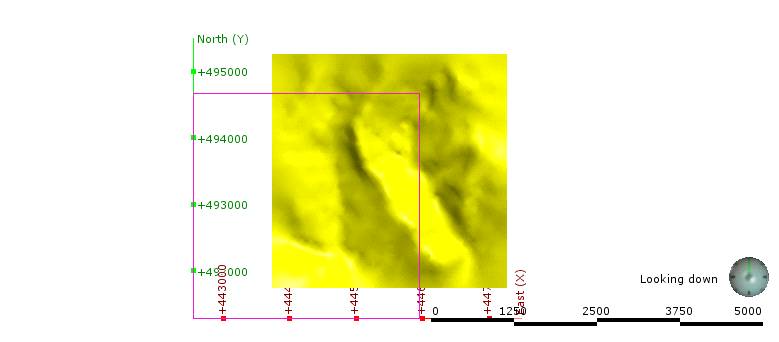
In order for Leapfrog Geo to be able to divide the model into separate volumes, the topography needs to be extended to enclose the model’s boundary or the model’s boundary needs to be restricted so it falls inside the topography. When the model is processed, the following error results:
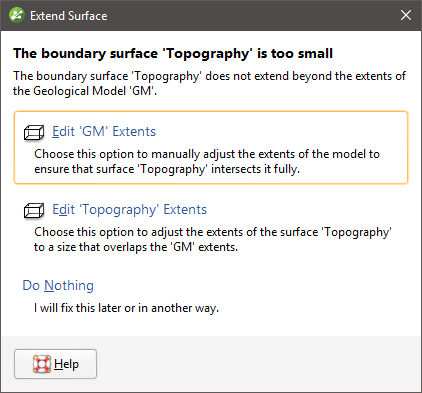
The solutions proposed will depend upon the data used to create the surfaces that conflict, but fall into three broad categories:
- Reduce the size of the model’s or interpolant’s extents. Click the Edit Extents button. This will open the object’s Boundary window and you can change the boundary.
- Enlarge the topography by manually adjusting it. Click on the Edit Topography Extents button. This option is only available when the topography has been created from more than one data source. See Adding Height Data to the Topography and Changing Topography Settings.
- Use the surface’s vertices to create the boundary or contact with extents large enough to be used in the model or interpolant. Click the Use Vertices button to create a new vertices object and use it as the source data for the boundary or contact.
If you have a solution to the problem that is not covered by the options presented, click Do Nothing. For example:
- If the topography is not large enough, there may be additional data available. If it is not already in the project, import the data and add it to the topography as described in Adding Height Data to the Topography.
- If a surface being used to define a contact surface or boundary in a geological model or interpolant is not large enough, you can add additional data to the surface.
Using vertices to create the boundary or contact results in the creation of a new points object that will be saved in the Points folder.
Earlier versions of Leapfrog Geo (up to 1.3) would automatically create the new vertices object and use it to interpolate the surface.
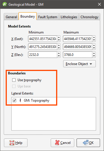
In the case of using topography vertices as an upper boundary, the vertices will be applied as a lateral extent and the defined topography will not be used. For example, here the geological model does not use the defined topography but instead uses the “GM: Topography” surface created from the vertices:
Using topography vertices can take some time to process.
An additional disadvantage to using vertices is that the vertices object created is not linked to the original object. When the object used to create the vertices changes, the vertices will not be updated.