
Posting
Use the Map Tools > Posting menu option (POST GX) to display the values of the data points in a channel on your map.
Posting dialog options
|
Post channel |
Select a channel to plot. Array channels: To post values for a particular column of data in an array channel, first select the array channel, then manually edit the value, adding the column number enclosed in square brackets. The columns are indexed from 0 to N-1, where N is the size (number of columns) of the array channel. For example, for channel “EM”, appending “[1]” to give “EM[1]” will result in the second column of values being posted. Script Parameter: POST.CHANNEL |
|
Posting size (mm) |
The size of posting characters. Script Parameter: POST.SIZE |
|
Posting colour |
Select a colour for the posting characters (16 colours to choose from.) Script Parameters: POST.COLOR |
|
Decimal places |
The number of decimal places for the posting characters. Script Parameters: POST.DECIMALS |
|
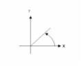
Post angle (deg CCW ) |
Angle for posting channel characters in degrees counter-clockwise from +X. Script Parameter: POST.ANGLE |
|
Angle relative to |
The reference line in which the posting angle is based on. Script Parameters: POST.FIXANGLE |
|
Posting location |
The posting location relative to the sample station (9 positions to choose from) Script Parameter: POST.JUSTIFY |
|
Horizontal offset (mm) |
Horizontal distance (mm) in which the postings are offset from the sample station. Script Parameters: POST.H_OFF |
|
Vertical offset (mm) |
Vertical distance (mm) in which the postings are offset from the posting station. Script Parameters: POST.V_OFF |
|
Plot dummy values in the posting? (No; Yes) Script Parameter: POST.DUMMY |
|
|
Base to remove |
Base value to remove from Z value before posting. For example, if the Z value is 60412 and the base is 60000, the posted value will be 412. (Default is 0.) Script Parameter: POST.BASE |
|
Detection limit |
All data less than the value typed in are posted as <# where # is the value entered (e.g. <300). The values below the detection limit are not profiled or plotted with variable size symbols. Script Parameter: POST.MINDETECT |
|
Alternate +/- |
Plot negative values on the opposite side of the plot point? (No; Yes) Script Parameter: POST.ALTER |
|
Reference channel |
Select a channel to use as a reference channel. Script Parameter: POST.REFERENCE |
|
Reference increment |
The reference increment is based on the reference channel. Posting will occur where the reference channel is an even multiple of the value entered. (Default is 1.0) Script Parameter: POST.MOD |
Application Notes
The "X" and "Y" channels are used to locate the posting by default. The X and Y offsets (in mm) are the offsets from that location to the posting reference point relative to the posting angle. The posting is then justified relative to the offset point and plotted at the specified angle.
For example, to post values centered 2mm. right of a point, enter an X offset of 2.0, Y offset of 0.0 and justify the text as "Middle left". Channels will be formatted as they appear on the spreadsheet.
You can also plot your postings based on a reference channel and specify the posting increment as an even multiple of the specified reference channel.
Plotted data is masked to the current data view’s clip region. Data outside the clip region is still written to the map, but is not visible. To see this data, uncheck the "Masked to view" box in the Map Manager tool.
For line-oriented Geoscience surveys, you may want to display 1D-profiles of the data values on each survey line.
Got a question? Visit the Seequent forums or Seequent support
© 2023 Seequent, The Bentley Subsurface Company
Privacy | Terms of Use