
Free Air Anomaly
Use the Gravity > Free Air, Bouguer Step by Step > Free Air Anomaly menu option (geogxnet.dll(Geosoft.GX.Gravity.FreeAirAnomaly;Run)*) to carry out the gravity free air correction.
Free Air Anomaly dialog options
Application Notes
This GX assumes that:
-
A gravity database is currently loaded (see Import Gravity Survey).
-
Latitude, Longitude ground locations are defined.
-
Tide, drift, base station absolute gravity (see Gravity Corrections) have been applied.
-
The Latitude correction (the theoretical gravity at the station location) has been applied (see Latitude Correction).
Elevation Channel
-
For ground surveys this is the elevation of the sensor, which equates to the topography plus the instrument height. However, if you have already applied a height correction in Gravity Corrections, then the elevation should represent the height of the topography above the datum (generally the geoid or sea level).
-
For airborne surveys at a constant barometric height, a free air correction is not necessary because the gravity values are at the same height. Nonetheless, you may want to reduce the data to the geoid surface in which case you could apply the free air correction. For drape airborne surveys, provide the flight elevation above the datum (positive up) . For drape surveys, if you have already applied a height correction, the elevation should represent the height of the topography to which you height-corrected the data.
-
For shipborne surveys, normally the elevation is constant and a free air correction is not necessary.
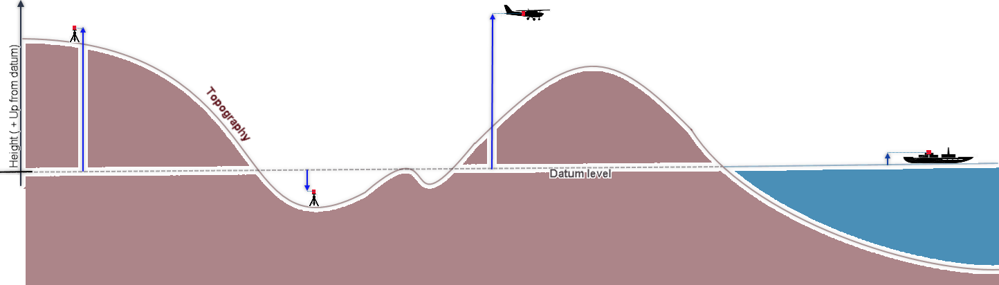
Figure 1: Height (elevation) relative to datum level.
Free Air Anomaly
In order to calculate the free air correction at an accuracy of 0.01 milligals, the station height should be provided at an accuracy of 3cm [Dentith et al, 2014]
The free air correction is calculated and added to the gravity corrected up to this point. The expressions for the supported corrections are:


Where:
Hs: the station elevation (relative to the datum, positive up)in metres L: the latitude of the station |
If you would like to provide alternate equation(s), define them in the file "Gravity_Free_Air.lst" located in the folder %USERPROFILE%\Documents\Geosoft\Desktop Applications \etc.
Each expression should be defined on one line and should consist of a unique name followed by the complete expression using the following syntax:

Where:
Input_Gravity: the variable containing the input gravity channel; designated by the variable $sGravity. |
In the expression, you can also use the variables:
$rEm: the conversion factor to convert the units of elevation to metres $sElevation: the elevation channel $sLatitude: the latitude channel |
For example, the syntax of the standard free air correction equation can be written as:


The last formula accounts for the non-line0.000000072124602\$rEm *\$sElevation) \$ rEm\$sElevation;{"}$arity of the free air anomaly as a function of both latitude and height above the geoid.
*The GX tool will search in the "...\Geosoft\Desktop Applications \gx" folder. The GX.Net tools, however, are embedded in the geogxnet.dll located in the "...\Geosoft\Desktop Applications \bin" folder. If running this GX interactively, bypassing the menu, first change the folder to point to the "bin" folder, then supply the GX.Net tool in the specified format.
References
- [1] W. A. Heiskanen and H. Moritz, Physical Geodesy, (San Francisco: W. H. Freeman and Company, 1967).
- [2] M. C. Dentith and S.T.Mudge, Geophysics for the Mineral Exploration Geoscientist, (Cambridge University Press, 2014), p. 103.
- [3] R. J. Blakely, Potential Theory in Gravity and Magnetic Applications, (Cambridge: Cambridge University Press, 1995), p. 135.
- [4] R. J. Blakely, Potential Theory in Gravity and Magnetic Applications, (Cambridge: Cambridge University Press, 1995), p. 136.
- [5] R. E. Sheriff, Encyclopedic Dictionary of Exploration Geophysics, 2nd ed., (Society of Exploration Geophysicists, 1984), p. 141.
- [6] R. E. Sheriff, Encyclopedic Dictionary of Applied Geophysics, 4th ed., (Society of Exploration Geophysicists, 1991).
Got a question? Visit the Seequent forums or Seequent support
© 2023 Seequent, The Bentley Subsurface Company
Privacy | Terms of Use