
NAR2 (Draw north and declination arrows)
The NAR2 command plots a north arrow on the map.
Command Syntax:
att,height,width,space,slant,font
Command Parameters:
|
refp |
Reference point from which to refer the following offsets. The default is reference point 1. |
|
xoff,yoff |
Offsets in map units from the reference point at which to place the north arrow symbol. The default is the current att position. |
|
direc |
North direction in degrees clockwise from map Y direction. The default is 0 degrees. |
|
length |
Length of the north arrow. The default is 60 cm. |
|
att |
Attribute to use. The default is att 1. |
|
incl |
Inclination of the geomagnetic field vector in decimal degrees. The label "Inclination" can be changed to a different language by setting the desired translation in the Mapplot_Translations.csv file in your %USERPROFILE%\Documents\Geosoft\Desktop Applications \csv directory. |
|
decl |
Declination of the geomagnetic field vector in decimal degrees. The label "Declination" can be changed to a different language by setting the desired translation in the Mapplot_Translations.csv file in your %USERPROFILE%\Documents\Geosoft\Desktop Applications \csv directory. |
Sub-Command Parameters:
This line can be used to set the text characteristics.
|
att |
Attribute for text. (default 1) |
|
height |
Character height. (default 7% length) |
|
width |
Character width. (default 6% length) |
|
space |
Character spacing. (default 6% length) |
|
slant |
Slant of the characters in degrees from vertical. The default is the last slant specified. |
|
font |
Text font (default is current font). Refer to the FONT command for descriptions of the available fonts. |
Example
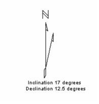
NAR2 3,-5,5,0,6,,17.0,12.5
Draws a 6 cm north arrow 5 cm left and 5 cm above the lower right corner of the map. The geomagnetic inclination and declination are annotated.
The labels "Inclination" and "Declination" can be changed to a different language by setting the desired translation in the Mapplot_Translations.csv file in your %USERPROFILE%\Documents\Geosoft\Desktop Applications \csv directory.
See Also:
Got a question? Visit the Seequent forums or Seequent support
© 2023 Seequent, The Bentley Subsurface Company
Privacy | Terms of Use