
Trend Enhancement
Aliasing and Trend Enhancement
The purpose of trend enhancement is to overcome the problem of data that is under-sampled in the across line direction. This is commonly referred to as an aliasing problem. Stated simply, when the width of anomalies observed down survey lines is narrower than the line separation, the gridding programs have difficulty interpolating the anomalies between lines. The best way to overcome this problem is by decreasing the line separation. However, this proportionally increases the cost of collecting data and is often not practical.
When designing line-based surveys, we try to minimize this problem by taking advantage of the inherent trend of the geologic strike. In practice this is done by simply orienting survey lines to be as perpendicular as possible to the strike, when it is known in advance. When the strike is not known in advance, or there is no predominant strike, it may be necessary to apply the trend enhancement techniques described in the sections below.
Local Trends
The regional trend enhancement procedure works very well when dealing with a single trend. However, when local trends exist, or there is not a single predominant trend, using the over-all trend method is not very effective.
Local trends are particularly difficult to deal with, because the joining of features between lines is subjective. Different people will join features in different ways, based upon their own experience and special knowledge of the geology of an area. To accommodate this human input, bi-drectional gridding (BIGRID) allows the insertion of manual trend lines. These are data lines in the XYZ file that simply include the points that we want joined on the map.
The most common procedure for adding manual trend lines is as follows:
-
Grid and contour the data using the default parameters wherever possible. Plot the results together with the survey plan.
-
From the resulting map, mark all line-to-line features that you would have joined on the final contour map as if the data had been contoured by hand. These trend lines can cross many lines, but they must be steadily increasing or decreasing in direction. If a trend does switch direction, break the trend into two lines at the point where the direction changes. Number trend lines consecutively starting at 1.
-
Edit the original XYZ file and carefully copy the data records that lie on each trend line, and add them to a new trend line at the end of the XYZ file. Each trend line must start with the line type TREND.
 The following listing is an example of an XYZ file that includes trend lines:
line -1600
-1600.00 330.00 330.00 419 -14 -3
-1600.00 325.00 325.00 415 -14 -3
-1600.00 312.50 312.50 406 -11 -4
-1600.00 300.00 300.00 406 -11 -4
-1600.00 287.50 287.50 401 -12 -4
.
.
.
-1600.00 -225.00 -225.00 393 -5 -6
-1600.00 -237.50 -237.50 389 -4 -6
-1600.00 -240.00 -240.00 390 * *
line -1500
-1500.00 -237.50 -237.50 393 0 -8
-1500.00 -225.00 -225.00 393 -1 -8
-1500.00 -212.50 -212.50 389 0 -8
.
.
.
-1500.00 325.00 325.00 398 -13 -4
-1500.00 337.50 337.50 396 -14 -4
-1500.00 350.00 350.00 398 -18 -4
.
.
.
trend 1
-1600.00 50.00 50.00 399 13 -8
-1500.00 125.00 125.00 391 -3 -10
-1400.00 200.00 200.00 409 -18 -7
-1300.00 287.50 287.50 421 -40 -10
trend 2
-1600.00 0.00 0.00 387 30 -2
-1500.00 62.50 62.50 397 23 -6
-1400.00 150.00 150.00 403 19 -8
-1300.00 250.00 250.00 406 -32 -5
trend 3
-1600.00 75.00 75.00 401 18 -6
-1500.00 150.00 150.00 380 14 -7
-1400.00 237.50 237.50 431 -10 -6
-
Run BIGRID using this new XYZ file as input. As the trend lines are treated the same as other survey lines in BIGRID, the resulting grid will be forced to honour the data along the trend. This results in the final map having those features joined together.
Re-orienting Trend-enhanced Grids
After initial gridding is performed to enhance a particular trend, the grid must be re-oriented to be square to the original coordinate system axis. Because the trends are already established, the grid can be re-gridded with rotation back to the initial coordinate system without loss of trend information.
This is accomplished by running BIGRID again, supplying a trend angle of zero in the BIGRID control file and giving the trend-enhanced grid in place of the XYZ file. For simply re-orienting grids, it is recommended that the filtering operations be turned off by not supplying ws and wl.
Regional Trends
When line-to-line correlation is strong due to geologic strike we can specify the predominant strike direction to the BIGRID. The program will attempt to join all features in this preferred direction. This is accomplished by rotating the across-line gridding direction of the output grid to be in the direction of the required trend.
The trend direction is defined by the "TRA" parameter in the BIGRID control file. Often, the predominant trend is not known until after the first attempt at creating a grid. In these cases, the trend direction should be left with its default value of zero for the first run of the BIGRID. Once the trend direction is determined by inspecting the grid, BIGRID can be run again using the correct trend.
Regional (Trend-enhanced) Gridding Overview
Trend-reinforced gridding is a method that enables you to grid in a specified direction and then return the grid to its original orientation. Trend gridding first creates a grid in the desired trend direction, then re-grids to the final grid, which is square to the map coordinate system. The temporary trend grid will be located in the project directory and will be deleted after gridding.
Optimizing Bi-Directional Line Gridding with Oblique Survey Lines
Many users grid their survey line data with BIGRID, and do not obtain optimal results because they do not realize they need to specify the line direction. If the line direction is very close to either north-south or east-west, BIGRID’s default settings are ideal. But if the survey lines are at other angles, you should override the default BIGRID settings to avoid odd streaking or other non-geological results. This approach will also enhance geological trends perpendicular to the line direction.
We recommend always following the procedure outlined below if your survey lines are not in the north-south or east-west orientations.
In the Grid Data dialog, specify the Trend angle (deg. ccw from +X).
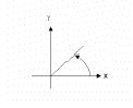
The "trend angle" is intended to enhance geological features in the direction specified. Since we ideally want to enhance features perpendicular to the survey line direction, this angle should be specified to be perpendicular to the line direction. Note that the angle to be specified is counter-clockwise relative to the positive X-axis (which normally points to the east).
For example, if your survey lines are oriented at N30E, you should specify a trend angle of either –30 degrees or 150 degrees. If your survey lines are oriented at N45W, you should specify a trend angle of 45 degrees.
Got a question? Visit the Seequent forums or Seequent support
© 2023 Seequent, The Bentley Subsurface Company
Privacy | Terms of Use