
Simulate Absolute Gravity Stations
Use the Simulate Absolute Gravity Stations option (geogxnet.dll(Geosoft.GX.Gravity.SimulateAbsoluteGravityStations;Run)*) to calculate Earth’s gravity at a given latitude and elevation.
The option is available with the Gravity and Terrain Correction extension under the following menus:
- Gravity > Gravity Corrections
- Moving Platform Gravity > Corrections by Steps
Simulate Absolute Gravity Stations dialog options
Application Notes
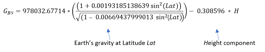
A base station database contains the absolute gravity value at specific longitude/latitude location(s) of established gravity base stations. The absolute gravity does not change with time and will be the reference base to level the survey data to. The absolute gravity should be in the vicinity of the survey area. Generally, the absolute base station gravity value will be close to the gravity value at that latitude and elevation above sea level. Using the Moritz gravity equation, given the base station height H above sea level at latitude Lat, the gravity value at the station should be approximately:
If there aren’t any stations in the vicinity of the survey to loop through during the survey, you can establish one. Gravity readings are relative to the established base station values. As long as you set properly a base station, you should be able to conduct the survey. Find a flat area away from the known dense geology to establish as your base station. This station will be then your reference station to level the data to.
To establish a base station reading, you can survey the gravity response at the established base station, then correct it for tide and drift, and then run the absolute gravity simulation at that location’s latitude. This is a single value per base station.
The latitude correction is in the order of 980,000 mGals. Prior to applying the latitude correction, gravity data is drift corrected and leveled to the base station absolute reading. If the base station is not in the order of 980,000 mGals, and rather at a much smaller magnitude, applying the latitude correction will yield gravity values in the order of -980,000 mGals, which is a source of confusion.
By allowing to set the base station to a range around 980,000, the final corrected gravity will be within an expected range.
*The GX.NET tools are embedded in the geogxnet.dll file located in the "...\Geosoft\Desktop Applications \bin" folder. If running this GX interactively, bypassing the menu, first change the folder to point to the "bin" directory, then supply the GX.NET tool in the specified format. See the topic Run GX for more details on running a GX.NET interactively.
See Also:
Got a question? Visit the Seequent forums or Seequent support
© 2024 Seequent, The Bentley Subsurface Company
Privacy | Terms of Use