About the Geosoft Database
The Geosoft database was initially designed in 1992 and has evolved to become a standard for airborne and ground geophysical data, geochemical data, and drillhole data of all kinds. Many commercial and governmental groups are currently employing the Oasis montaj system for routine processing of high-volume datasets (tested up to 10 gigabytes) and also for relatively low-volume processing in a variety of mapping and other applications.
One key to the system’s capabilities is the proprietary database architecture compared with conventional relational databases.
The Geosoft database is essentially a file (*.GDB) that contains all the data from a single survey project. Unlike conventional relational databases, a Geosoft database is an object-oriented database that stores 3D spatial (Earth Science) data in a form that enables fast access to data, rapid processing and analysis of high-volume data, and efficient storage demanded in applications that deal with very large volumes of data. The system supports a variety of data types and display formats.
How Do Geosoft Databases Work
The database data is displayed and organized in a spreadsheet window, and it can be thought of in three dimensions: element, channel, and line.
The spreadsheet window organizes and displays data differently than conventional (relational) spreadsheet and database programs.
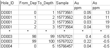
Conventional databases organize data as tables, records and fields, as shown below:

This is effective for querying and searching type applications but limits it as a data processing engine for the following reasons:
-
Programs must read an entire record to access a single field.
-
It is computationally intensive to change record structures.
-
Data sampled at different intervals and starting points are difficult to store.
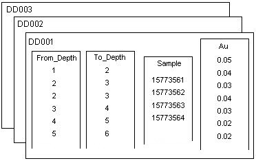
Oasis montaj is based on a proprietary 3-dimensional-file format architecture that overcomes these limitations, as shown below:

Organized in lines (or groups), channels and elements, the database stores all data values of a particular type in individual channels. This enables stand-alone processing of columns and eliminates the need to write results to interim storage areas and then rewrite them after processing. The result is a significant increase in processing efficiency. This file structure provides additional advantages including:
-
Ability to process any number of lines/groups.
-
Ability to handle lines/groups with unlimited columns.
-
Ability to handle very large datasets.
You can grid database channels and create 2D grid files and 3D voxel files using Oasis montaj 2D and 3D gridding options.
The Database Components
Elements
An element is the smallest item stored in a database. It can be a number or a text string that is related to a specific fiducial value. A fiducial is a numbering scheme that is used to relate elements from different data sources.
Element types can be byte, ushort (unsigned 2-byte integer), short (2-byte integer), long (4-byte integer), float (4-byte real), double (8-byte real) and string (a fixed length text string).
Channels
A channel is an array of elements, consecutively related, based on a fiducial increment. The first element of a channel has an assigned start fiducial, and subsequent elements are separated by a fiducial increment. A channel also has a name and a display format. Channel names must start with a letter or an underscore character ‘_’, and may not contain any spaces.
Once a channel is defined, it exists on all lines of a database. However, it may or may not contain data (elements). A channel may contain any number of elements, all of which are the same data type.
Lines
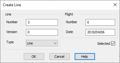
A database line is a collection of channels that are related to a single survey line. Each line has a line type, line number, version number, flight number (only required for airborne data), survey date, and selection status.

If the data comes from a ground exploration survey, you can base fiducial numbering on the survey station numbers. If the data comes from an airborne survey, the fiducial numbers are obtained directly from the airborne data acquisition system.
It is important to understand that the sample increment (fiducial increment) of each channel on a line may be different, but data between channels is related based on the fiducial number. For example, a magnetic survey might have four lines numbered 100, 200, 300 and 400. Each line might have channels of "X", "Y" and "Mag", which represents the surveyed locations and magnetic readings. Each channel on each line will have a certain number of data values, which depends on the length of the line and the sampling increment.
Line Format Identifiers
The top left cell in the spreadsheet window, called the ID cell, displays the identifier for the data group you are currently using.
If the line name is preceded by a checkmark, it indicates that the line is also selected for processing:
![]()
Various processes within Oasis montaj can be applied to lines that are selected at the time the process is run.
Typically, this identifier corresponds to a survey line on which the corresponding data was acquired. The general format of the line identifier (used in the ID cell of the spreadsheet window) is:
TYPE number.version:flight
Types of Survey Lines
In Oasis montaj, you can specify any of the following types of survey lines:
|
Type |
Description |
|
B |
Base lines |
|
D |
Random Lines |
|
L |
Normal lines |
|
P |
Special lines |
|
R |
Trend lines |
|
S |
Test lines |
|
T |
Tie lines |
For example, "T110.2:16" is tie line 110, version 2, from flight 16. The combination of line type, line number and version number must be unique within a single database. This means there can only be one "T110.2" in a database, regardless of the flight number.
Groups
A "group" is a special kind of line. It also stores data in channels, but instead of using a name based on line number, version number, line type and flight number, it can be named using any alpha-numeric string (with some exceptions).

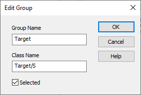
Each database "group" line has an optional "CLASS" name. Like a regular line, it has a selection status.

While all the channels in a database are accessible inside a regular line, a group line can restrict the available, displayable channels to a smaller subset, excluding those not relevant to the group’s data.
Background
Geosoft databases were initially developed to store and process airborne and ground geophysical datasets and were designed to contain both "lines" and "channels". Every channel in a Geosoft database can be selected and viewed from every line. If you create and display a new channel, it is immediately visible in every line in the database.
"Groups" were introduced to accommodate our drillhole application ("Target") so that different kinds of drillhole data could be stored in a single database. The "group" concept was created so that you could have lines where only a subset of the channels would be available, the ones that were specifically "associated" with the group. In the early drillhole databases, a collar table group would have certain channels, a survey group would have other channels, and you could look at the collar table "line" without worrying about the clutter of showing all the other unrelated channels in the database (like the "From" and "To" channels found in down-hole data).
The group "CLASS" concept was introduced in an attempt to make all groups of a particular type (e.g., surveys, from-to data, etc.) behave the same way when it came to channels loaded, profiles displayed, etc., by assigning the same CLASS name to each group in the collection of like items. If a group doesn’t have a class defined, it is treated in isolation with its own unique set of associated channels.
The Target (drillhole) application now uses a multi-database model, where each type of drillhole data (collar table, survey, assay, etc.) is stored in its own unique database. All lines/groups in any drillhole database are of the same CLASS, and all the channels are relevant to all the lines, as only one type of drillhole data is stored in a single database.
The mixed "line/group" database model has been implemented in other Geosoft extensions, such as UXO, Gravity/Magnetic Interpretation (Euler), and Gravity and Terrain Correction.
A database may contain any number of lines and/or groups. If your survey data has not been collected on a line basis (is random), or cannot be organized conveniently into groups that can be thought of as lines (such as drillhole or UXO target data), you can store all data in a single line.
Geosoft database files are made up of straight binary data. You can learn how to write and process database files directly with GX Developer – the Geosoft GX API developed to create stand-alone programs that read and/or write to Geosoft supported file formats. To learn more, see the Geosoft Databases section under the
Got a question? Visit the Seequent forums or Seequent support
© 2024 Seequent, The Bentley Subsurface Company
Privacy | Terms of Use
