
Merge DEM and Bathymetry
Use the option Merge DEM and Bathymetry (geogxnet.dll(Geosoft.GX.Gravity.MergeDEMandBathymetry ;Run)*) to merge your DEM and bathymetry data into a single output grid.
The option is available with the Gravity and Terrain Correction extension under the following menus:
- Gravity > Terrain Corrections
- Moving Platform Gravity > Terrain Corrections
Merge DEM and Bathymetry dialog options
|
DEM grid |
Select the DEM grid name. The output grid will be at the same projection and vertical datum as this grid. Script Parameters: MERGE_DEM_AND_BATHYMETRY.DEM |
|
Bathymetry grid |
Select the bathymetry grid name. This grid should be at the same projection and vertical datum as the DEM grid, and if needed it will be regridded to be merged with the DEM grid. Script Parameter: MERGE_DEM_AND_BATHYMETRY.BATHYMETRY |
|
Output grid |
Specify the name of the output merged DEM and bathymetry grid. If there are gaps between the two input grids, run the REGRID GX from the Regrid a Grid > Grid and Image > Gridding menu. Script Parameter: MERGE_DEM_AND_BATHYMETRY.OUTPUT |
|
Output size |
Select the output size to match the DEM grid, the bathymetry grid, or the combination of the two. Script Parameter: MERGE_DEM_AND_BATHYMETRY.SIZE |
|
Overlap |
Select the desired action in the overlapping areas of the two grids. The default is "DEM-Bathymetry ". See the Application Notes section for more details. Script Parameter: MERGE_DEM_AND_BATHYMETRY.OVERLAP |
Application Notes
*The GX.NET tools are embedded in the geogxnet.dll file located in the "...\Geosoft\Desktop Applications \bin" folder. If running this GX interactively, bypassing the menu, first change the folder to point to the "bin" directory, then supply the GX.NET tool in the specified format. See the topic Run GX for more details on running a GX.NET interactively.
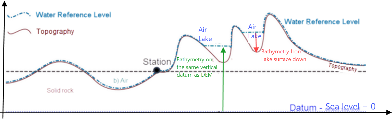
Overlap
-
If the vertical datum of the bathymetry grid has its zero on the surface of the water and is positive downwards (red arrow in the illustration below), choose DEM-Bathymetry for overlap.
-
If the DEM and bathymetry grids are provided in the same vertical datum (green arrow in the illustration below), choose Bathymetry for overlap.
-
If the footprint of the bathymetry grid consists mostly of dummies in the DEM grid with a small overlap along the contact of the two grids, then the bathymetry grid must be provided on the same vertical datum as the DEM grid, and the overlap can be averaged. In this case use the Average option. This option performs a simple averaging in the overlap areas. If the nature of the two input grids is very different, we recommend that you use GridKnit (see the Knit Grids Together topic).
-
The option DEM would be used if the intent is to make the output footprint of the DEM grid match the footprint of the bathymetry grid.
If you transfer the projection of the bathymetry grid to the output merged grid, swap the DEM and Bathymetry parameter entries.
Got a question? Visit the Seequent forums or Seequent support
Copyright (c) 2025 Bentley Systems, Incorporated. All rights reserved.
Privacy | Terms of Use