
XYZGMS
XYZGMS is a command-line driven
Application Notes
XYZGMS reads free format ASCII files, (i.e. fields of data separated by spaces). Data fields can be in any order you chose. Geosoft line headers need to be present. You select which 'Line' will be used for building the model.
Capabilities
- Window and decimate your data to a subset of your data file
- Select default values for missing data types (e.g. magnetic station elevations)
- Create all necessary files for a
GM‑SYS model including conveniently recalled views - Specify a starting X-coordinate offset
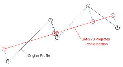
Multi-segment Lines
Note that XYZGMS converts a multi-segment line into a single-segment profile as shown below. The black line represents the original profile as digitised by the user. The red line is the location of the model profile in real-world X,Y space with values projected perpendicularly onto the model profile. The model-profile azimuth is based on the first and last points in the original profile. The profile location is then shifted to minimize the average mis-fit.
The first point in the model will be placed at X=0 (
Profile Azimuth
XYZGMS calculates the profile azimuth and generates a transformation between the profile (X’Z) coordinates and the original input (XYZ) coordinates. The coordinate transformation is saved in <out>.ECS and is used by GM-SYS Profile Modelling to recover the original XYZ coordinates for surface export, grid output, and interaction with third-party software, such as Geosoft’s Oasis montaj™. XYZGMS assigns relative strike angle=90, magnetic inclination=60, declination=20 and field intensity=56,000 as default values. You may change these for each model in GM-SYS Profile Modelling (Profile menu, set field and set azimuth) to the proper values for your profile.
Example
XYZGMS test test -l=L19 -d=5 -t=400 -eg=400 -zg=5
This example will read data from file test.xyz and create a GM-SYS Profile Modelling model named "test". Only every 5th point will be read, topography elevation is constant at 400 meters, gravity data is in the 5th field of the input data file, and the elevation of the gravity stations is constant at 400 meters.
Sample Files
Two sample files are included with the distribution:
- gms.xyz is a sample input data file
- sample.bat is a sample batch file using gms.xyz
Specifications
Maximum number of columns (characters) in input record, 256 maximum number of data fields in input file: 50, maximum number of data points in output model: 16,000.
Got a question? Visit the Seequent forums or Seequent support
© 2024 Seequent, The Bentley Subsurface Company
Privacy | Terms of Use