
GeoQuest® Card Image 7 Files
CVTGMS imports horizons and faults exported in GeoQuest 2-D Card Image 7 format, a common export format available in Seismic Micro-Technology's The KINGDOM SuiteÔ and other seismic modelling and interpretation packages. Fault and horizon files from an exported profile should be concatenated together prior to importing the file into CVTGMS.
CVTGMS exports all model surfaces as Card Image 7 faults, because fault nodes do not need to fall on shot-point locations, whereas horizons are only defined at shot-point locations and can not be multi-valued at a single (X,Y) location.
Minimum and Maximum (X,Y) data extents are used to define the line onto which the X,Y coordinates are projected to generate the model X-coordinates.
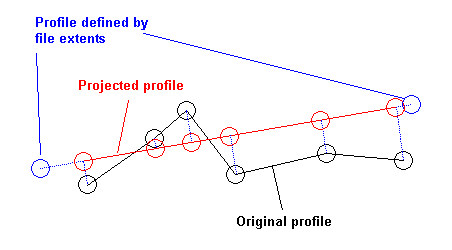
The calculated model X-coordinates and the calculated min/max Z-coordinates of the profile define the "Full" view.
CVTGMS saves all of the coordinate transform information in the .ECS file, so that the projected (X,Y,Z) coordinates may be recovered when a
This process will "straighten" profiles that "bend" and that the original Y-offset from the profile cannot be recovered.
Got a question? Visit the Seequent forums or Seequent support
© 2024 Seequent, The Bentley Subsurface Company
Privacy | Terms of Use