Adding Data to Surfaces
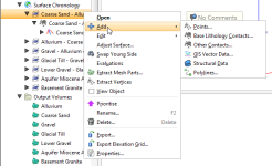
Select the type of data you wish to use to modify the surface. Leapfrog Geo will display all the suitable objects in the project. Select the required object and click OK. A hyperlink to the added data will appear under the surface in the project tree. The added data can be removed from the surface by expanding the surface in the project tree, then right-clicking on the hyperlinked data object and selecting Remove.
Contact Honouring
In Leapfrog Geo, surfaces can be created from drillhole data, points data, structural data, GIS data and polylines. When surfaces are created from several different objects, it may be desirable to snap the surface to some data objects but not to others.
There are several options for snapping surfaces to data:
- Off. The surface does not snap to the data used to create it.
- All data. The surface snaps to data within the Maximum snap distance, which includes drillhole data and any data added to the surface.
- Drilling only. The surface snaps to drillhole data and data objects derived from drillhole data within the Maximum snap distance but not to other data used to modify the surface. For example, the surface will honour points data derived from drillhole data, but not points data imported into the Points folder.
- Custom. The surface snaps to selected data objects within the Maximum snap distance.
Snapping to data is off by default. Although you can snap to all data, this is not recommended as it increases the possibility that errors in the data or assumptions inherent in interpretations (e.g. polylines) will cause distortions in the meshes. If you do enable snapping, is best to snap only to drilling data.
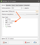
For example, here the Snap to data has been set to Drilling only for a mesh created from multiple data objects:
Note that the only objects Snap is enabled for are the contacts derived from drillhole data.
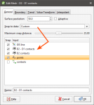
Here, Snap to data has been set to Custom, which makes it possible to enable Snap for only the selected data objects:
In Leapfrog Geo, the snap settings for different types of surfaces can be controlled as follows:
- For geological models, Snap to data can be set for the model as a whole, but individual surfaces can have different settings. For more information, see:
- For editable interpolated meshes and offset meshes (
 ), Snap to data can be set by double-clicking on the mesh and changing the settings in the General tab. See Refining an Interpolated Mesh and Offset Meshes for more information.


