Interactive Shading
The Interactive Shading tool enables you to interactively adjust the shading parameters (colour saturation, inclination, declination, scale, brightness and contrast) of the active grid. The parameters settings will be retained and saved upon closing the dialog.
Interactive Shading dialog options
|
Shadow grid
|
Initially, the grid used to create the shadow image populates this entry. You could, however, select a different coinciding grid, such as a topography grid, to generate the shading from.
The "shadow grid" should cover or exceed the area of the data grid.
|
|
Wet look
|
Check this box to allow the image colour saturation to vary with the sun angle in conjunction with the grey scale.
In this mode, as the local slope of the shadow of a grid cell approaches the normal to the sun angle, in addition to the grey shading becoming lighter, the colour saturation of a cell decreases. This option gives the colour image a look similar to the reflection of the surface of water.
Leave this option unchecked if a full colour saturation is desired.
|
|
Inclination
|
Initially, the sun angle inclination (height above the horizon) is set to 45°. You can change the inclination using either the arrow keys or by entering an exact value. The change takes effect immediately on the active grid.
You could lock this parameter during interactive shading by clicking on the lock icon located to the right of this field.
Only one of the illumination parameters (Inclination or Declination) can be locked at a time.
|
|
Declination
|
Initially, the sun angle declination (azimuth angle from north CW ) is set 45°. You can change the declination using either the arrow keys or by entering an exact value. The change takes effect immediately on the active grid.
You could lock this parameter during interactive shading by clicking on the lock icon located to the right of this field.
Only one of the illumination parameters (Inclination or Declination) can be locked at a time.
|
|

|
Click this button to interactively change the sun angle. The mouse cursor will change to  , to indicate that you are in the interactive mode on the map. Next, click on the active map/grid view to commence the interactive shading. As you move the sun cursor on the map, the direction of shading will update in real time. The inclination/declination parameters will be interactively updated in the status bar of the image window. The inclination/declination in the dialog will be updated once you click the left mouse button again to conclude the interactive shading. , to indicate that you are in the interactive mode on the map. Next, click on the active map/grid view to commence the interactive shading. As you move the sun cursor on the map, the direction of shading will update in real time. The inclination/declination parameters will be interactively updated in the status bar of the image window. The inclination/declination in the dialog will be updated once you click the left mouse button again to conclude the interactive shading.
|
|
Scale
|
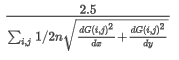
The scale factor controls the shading intensity. This parameter is entirely dependent on the grid data distribution and can vary by many orders of magnitude. The default scaling factor yields a perceptually balanced amount of shading.
The default scaling factor equation is provided in the Application Notes below.
If you find the contrast too strong and the vertical appearance exaggerated, reduce the scale factor. If the image is too flat, increase the scale factor.
|
|
Brightness
|
Set the brightness level for the shaded grid. The normal brightness is defined at 100%.
You can change the brightness from 0% ("cloudy") to 100% ("clear skies") using the slider bar.
The "brightness" setting is visually more effective with a Normal colour scheme.
|
|
Contrast
|
Set the contrast level for the shaded grid. The normal contrast is defined at 50% .
You can change the contrast from 10% ("midday") to 100% ("dusk") using the slider bar.
While the brightness shifts the shading towards darker or lighter shades, the contrast varies the range of shading.
|
Application Notes
Shading and Scaling
The scale determines how the shading tool interprets the values in your grid. For example, if you use a large scale, you will exaggerate the vertical appearance of your grid and see deep valleys. If you use a very low scale, you will flatten the grid and see very smooth hills.
The stronger the data variation, the shorter the shadows and the faster the progression from dark to light. In addition, the higher the illumination inclination from the horizon, the shorter the progression from dark to light. To balance the shading to accommodate a wide range of data distributions and illumination angles, the shadow distribution is widened for strong data variations and high illumination angles through the use of the scale factor.
The shadow grid is thus calculated using the following equation:
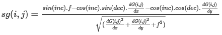
Where:
sg: shadow grid
i,j: ith row & jth column grid indices
inc: illumination inclination
dec: illumination declination
f: 1/scale factor
dG(i,j)/dx: gradient of the i,j grid point in the X direction
dG(i,j)/dy: gradient of the i,j grid point in the Y direction
The default vertical scale factor is set to 2.5 over the mean of the gradient of the input grid: