
Set Coordinate System
Use the Coordinates > Set Coordinate System menu option (SETCHPRJ GX) to assign a coordinate system to a coordinate channel pair in a Geosoft database.
Set Coordinate System dialog options
|
X channel |
Select the X channel. Script Parameter: SETCHPRJ.X |
|
Y channel |
Select the Y channel. Script Parameter: SETCHPRJ.Y |
|
Set as current X,Y? |
If Yes, the selected X and Y channels are made the "current" X and Y channels for the sake of any GX which requires an X and Y channel, but which does not specifically ask for the names of those channels. Script Parameter: SETCHPRJ.SETCURRENTXY (0: "No", 1: "Yes" – default is "Yes") |
|
[Coordinate System] |
Select this button to display the current coordinate system assigned to this channel pair. The Coordinate System wizard will open to enable you to view and modify a coordinate system. |
Application Notes
Map projection is a systematic representation of all or part of a curved surface on a plane. Since this can not be done without distortion, you must choose the characteristics to be shown accurately at the expense of others. Projections are infinitely varied according to the choice of the points on earth to represent accurately. Figure 1[1] illustrates the different ways to project curved surfaces on a plane, consisting of cylindrical, conic or azimuthal projections.
The cylindrical and conic projections may be tangential to the spherical surface (one central meridian) or can cut through it (2 meridians). The tangential transverse cylindrical projection is the most common projection; this projected plane may also touch the sphere at any oblique angle.
Earth is nearly an oblate ellipsoid, but not an exact ellipsoid – deviations from this shape are continuously evaluated. The shape is known as the Geoid, which is this undulating (by no more than ±100 m) shape that the Earth assumed if it where all measured at sea level. Two geometric constants suffice to define the ellipsoid: the major axis and the flattening. There are numerous principal ellipsoids used in different parts of the globe because the curvature of the Earth is not uniform due to the gravity field.
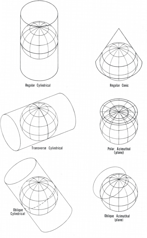
Figure 1 - Projection of the Earth onto the three major surfaces. In a few cases, projection is geometric, but in most cases the projection is mathematical to achieve certain features.
To assign a coordinate system from a script:
Define the coordinate system using the following parameters. Note that the syntax of the setting conforms to the GXF revision 3 naming convention:
Reference
- [1] John P. Snyder, 1987, "Map Projections - A Working Manual", U.S. Geological Survey Professional Paper, vol. 1395.
See Also:
Got a question? Visit the Seequent forums or Seequent support
© 2023 Seequent, The Bentley Subsurface Company
Privacy | Terms of Use