
Defining the Projection of Database Channels
A projection can be defined from any pair of channels in a database. These two channels must contain coordinate information. Normally, the X and Y coordinate channels are used.
To assign a coordinate system, you must know the coordinate system that the data was collected in. If the wrong coordinate system is specified, the system may display the data incorrectly, in the wrong place, or take an usually long time to process. Usually with geographic data, the coordinate system and projection methods are known and provided with the data.
The Coordinate System tool allows you to specify the coordinate system, the length units, the datum, local datum transform and projection method for your data.
Set a Coordinate System for Database Channels
-
Open a Database that contains at least two channels with coordinate information (x, y).
-
.
-
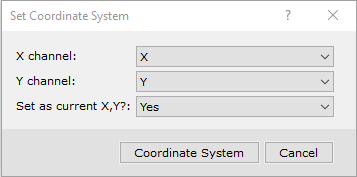
Select the X and Y coordinate channels that you will use to set the projection.
-
Click the Coordinate System button. The system displays the Coordinate System dialog.

Whenever you work with projections in Oasis montaj, the projection information for the current database, grid, or view is displayed in this dialog box. When the fields in any dialog box are shaded grey, you can only view the information. If the dialog box fields are white, you may edit the values.
Change Coordinate Channels in a Database
In order to plot georeferenced data on a map, the channels that contain the coordinate information, must be identified as X and Y. The reason for this is that the GX that plots database information on a map always looks for coordinate information in the X and Y channels. If these channels are not identified, the system will not know where the coordinate information is in the database.
Oasis montaj provides the ability to create new x, y, and z-coordinate channels from the channels that contain the existing coordinate information.
To perform this procedure, you must have two channels that contain projection coordinates (i.e., latitude and longitude).
-
On the Coordinates menu, click Set Current X,Y,Z. The system displays the Set Current X,Y,Z dialog box.
-
Select the channels you want to use for the new X, Y, and Z coordinates. Click OK.
- The system sets the channels you specified as the X, Y, and Z channels with a blue x, y, z in the channel header.
Got a question? Visit the Seequent forums or Seequent support
© 2023 Seequent, The Bentley Subsurface Company
Privacy | Terms of Use