Voxel Properties

Use the Voxel > Properties menu option (geogxnet.dll(Geosoft.GX.VoxUtils.VoxStat;Run)*), to report and modify information about a Geosoft Voxel, including simple statistical information and coordinate system information.

Voxel Properties dialog options

This dialog is designed as a "wizard" that presents information depending on what you want to see or do.

Voxel Properties (1)

The first dialog enables you to select the voxel file that you are interested in:

Voxel

Select the voxel file to report.

Next>

Select this button to display basic voxel information together with options to see other information or to change certain information.

Voxel Properties (2) 

All the basic information about the voxel is reported in this dialog.

Voxel

Displays the name of the voxel

Element type

Data element type. Usually FLOAT or DOUBLE.

Number of cells X,Y,Z

The number of voxel cells in each direction. See Modify for more information.

X,Y,Z voxel cell sizes

The sizes of each voxel "cell" in the X, Y and Z directions, starting at the bottom left corner of the voxel model.

Origin X,Y,Z

The location (in the coordinate system noted below) of the centre of the bottom left cell of the voxel model. See Application Notes below for an illustration. 

Rotation about Z (Yaw)

Clockwise angle of rotation around the Z-axis. See Modify for more information.

Z Orientation

Up (Standard) or Down (Inverted). See Modify for more information.

Coordinate system

This displays the map coordinate system projection of the voxel, if any. Use the Modify button to modify the coordinate system projection.

Coordinate system units

This displays the length units of the coordinate system. The voxel origin and point separations are in these units. Use the Modify button to modify the coordinate system projection and units.

The following table describes the function of each of the buttons.

<Back

Select this button to return to the Voxel Statistics dialog.

Stats

Displays the Voxel Statistics or the Lithology Voxel Stats dialogs, which present basic statistical information about the data in the voxel. From the Voxel Statistics dialog, you also have the opportunity to display a histogram of the data distribution.

Modify

This will enable you to change voxel location and coordinate system projection information. See "Modify Voxel Properties" below.

  • The Modify button is only available with the Oasis montaj Licensed Processing Engine.
  • Exit

    Select this button to exit the voxel statistics wizard.

    Help

    Select this button to retrieve Application Help information.

    Voxel Statistics

    All basic statistical information about the voxel is reported. The information labels are self-explanatory. The following table describes the function of each of the buttons.

    Histogram

    Select this button to view a histogram of the voxel data distribution.


    <Back

    Select this button to return to the Voxel Statistics dialog.

    Modify Voxel Properties

    The information displayed in this dialog is used to locate the voxel in a real coordinate system. This information can be changed. Note that changing anything in this dialog will have the effect of moving or changing the apparent size of the voxel when displayed on a map.

    Voxel

    Displays the name of the voxel

    X voxel cell sizes

    The voxel cell size in the voxel X direction. Non uniform cell sizes are handled by a list of values. This list may include 50x300 syntax (i.e. 50 cells with 300m dimension). You can change the cell sizes using this convention.

  • Geosoft voxels actually store the centre of the voxel cell as a point.
  • Y voxel cell sizes

    The voxel cell size in the voxel Y direction, in the same syntax as for the X voxel cell size.

    Z voxel cell sizes

    The voxel cell size in the voxel Z direction, in the same syntax as for the X voxel cell size.

    Reference Point

    Bottom XY or Top XY. The location of the Real Origin (x,y,z) that follows can either be the (x,y) origin of the top, or the bottom of the voxel model.

    If you change the Reference Point to Top XY, the location of the Real Origin will not automatically recalculate – you must set the Z value for the Top XY location.

  • When you close the Modify Voxel Properties dialog, the Z location of the bottom XY origin will be calculated and stored in the voxel. When the Modify Voxel Properties dialog is re-opened, you will always see the Bottom XY origin information.
  • Real Origin X

    The X location of the Reference Point in the coordinate system. The location of the Reference Point is the point at the center of the cell specified by the Reference Point.

    Real Origin Y

    The Y location of the Reference Point in the coordinate system

    Real Origin Z

    The Z location of the Reference Point in the coordinate system. If Z orientation is up (see below), the Real Origin Z should be the elevation of the Reference Point. If Z orientation is down, the Real Origin Z is the depth below ground to the reference point, usually 0 if using the Top XY corner of the voxel as the reference point.

    Rotation about Z (Yaw)

    Clockwise angle of rotation around the Z-axis. An angle of 0.0 implies that the voxel X axis points East and the voxel Y axis points North in the reference coordinate system.

    Rotation about X (Roll)

    Clockwise angle of rotation around the X-axis, usually 0.0.

    Rotation about Y (Pitch)

    Clockwise angle of rotation around the Y-axis, usually 0.0.

    Z orientation

    Z up (standard) or Z down (inverted). Z up usually implies that Z represents elevation relative to the coordinate system datum. Z down usually implies that Z represents depth below ground.

    Coordinate system

    This displays the projected map coordinate system of the voxel, if any. Use the CoordSys button to modify the coordinate system projection. Note that voxels must always be defined on a projected coordinate system. Voxels based on a geographic coordinate system (latitude, longitude) are not possible.

    Coordinate system units

    This displays the length units of the coordinate system. The voxel origin and point separations are in these units. Use the CoordSys button to modify the coordinate system projection and units.

    <Back

    Select this button to return to the Basic voxel report dialog.

    CoordSys

    The CoordSys button will run the Coordinate System Wizard to enable you to view and modify the projection information.

    Application Notes

    *The GX.NET tools are embedded in the geogxnet.dll file located in the "...\Geosoft\Desktop Applications \bin" folder. If running this GX interactively, bypassing the menu, first change the folder to point to the "bin" directory, then supply the GX.NET tool in the specified format. See the topic Run GX for more details on running a GX.NET interactively.

    This dialog will only allow you to look at and modify information about a voxel. No data contained in the voxel will be changed.

    Voxel Origin 

    ../../geohelp/image/voxeldiagram.png

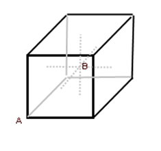
    A Voxel is created surrounding a data point, therefore the data point is at the centre of a voxel cube, shown as data point B above. The "voxel origin" is the lower left corner of the voxel cube, shown as data point A above, which is determined based on the voxel cell size.

  • You need to specify either a single value or the correct number of values.