
Geostring Snapping
To enable snapping while digitizing geological features on a section map, click the Toggle Snapping button on the Geostrings Toolbar to turn it on. When snapping is on, the Toggle Snapping button will appear with a shaded border. Snapping enables you to be more precise when digitizing interpretations on section maps. From the Snap To list, you can select a drillhole table under True Drillhole Locations or a Projected Map Group, or Geostring Features.
The digitizing cursor (crosshairs) will change to the snapping cursor (crosshairs with red circle) when it comes within 10x10 pixels of the specified Snap To item. The circle will change to pink when snapping to features that are off the plane of the section including true drillhole locations or geostring features that are off section. While digitizing, snapping can be turned off by right-clicking and selecting Snapping from the context menu. The Snap To item can also be changed from the context menu.
True Drillhole Locations
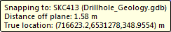
The cursor will snap to the true X, Y, Z location along the drillhole trace for the interval or point in the specified drillhole database. If you enable the snap cursor to rest for a moment, a tooltip will display showing the following information:
-
The hole ID and drillhole database.
-
The distance from the centre plane of the section (negative values for points behind section plane, positive values for points in front of section plane).
-
The true X, Y, Z coordinates of the point.
Example:
Projected Map Groups
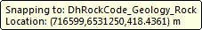
The cursor will snap to the X, Y, Z location of the specified vector map group projected onto the centre plane of the section. If you enable the snap cursor to rest for a moment,a tooltip will display showing the following information:
-
The map group being used for snapping.
-
The X, Y, Z coordinates for that point on the centre plane of the section.
Example:
Geostring Features
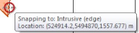
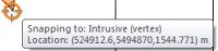
The cursor will snap to the X, Y, Z location of a vertex of an existing geostring feature that has already been digitized on the map. If you enable the snap cursor to rest for a moment, a tooltip will display showing the following information:
-
The name of the geostring feature being snapped to
-
If the snapping point is a "vertex" or "edge" (the snapping circle will appear orange when a vertex is selected)
-
Distance off plane (only when the vertex of the feature is snapped to a true drillhole location)
-
The X, Y, Z coordinates of the point, on or off the plane of the section
Example:
|
|
Got a question? Visit the Seequent forums or Seequent support
© 2024 Seequent, The Bentley Subsurface Company
Privacy | Terms of Use