
IGRF at a Point
Use the IGRF > IGRF at a Point option (geogxnet.dll(Geosoft.GX.Igrf.Igrfpt;Run)*) to compute the International Geomagnetic Reference Field (IGRF) or the Definitive Geomagnetic Reference Field (DGRF) model values for a single point at a specified date.
The option is available with the following extensions and menus:
- Geophysics: IGRF
- Geophysics Leveling: Tie Line Levelling > Levelling Corrections
IGRF at a Point dialog options
|
Date (yyyy/mm/dd) |
Specify the required date using the format yyyy/mm/dd. Script Parameter: IGRFPT.DATE |
||||||
|
Position format |
The default position format (“Normal”) for the Latitude/Longitude coordinates is decimal degrees. Use the drop-down list to select a geographic format: the Latitude and Longitude parameters below will redisplay the coordinates based on the selected format. The Latitude/Longitude coordinates are displayed in the user specified format, but they will be converted to decimal degrees for processing.
For a list of supported "Geo" formats, check the topic Data Types and Database Formats. Script Parameter: IGRFPT.POSITION_FORMAT |
||||||
|
Longitude |
Specify the longitude using one of the options below:
Script Parameter: IGRFPT.LONG |
||||||
|
Latitude |
Specify the latitude using one of the options below:
Script Parameter: IGRFPT.LAT |
||||||
|
Elevation (m) |
Specify the elevation in metres (0 for sea level). Script Parameter: IGRFPT.ELEV |
||||||
Output |
|||||||
|
[Calculate] |
Click on the Calculate button to calculate and populate the IGRF parameters below. The field strength, inclination, and declination will be calculated based on the input values and will be displayed in the bottom three fields of the dialog. You may change the input parameters and recalculate the results. Click Close when you are done.
|
||||||
Application Notes
The International Geomagnetic Reference Field (IGRF) is the empirical representation of Earth’s magnetic field as a function of time, in the absence of any crustal or external sources. The model employs the spherical harmonics expansion of the scalar potential in geocentric coordinates. The IGRF model coefficients are based on all available data sources, including geomagnetic measurements from observatories, ships, aircraft, and satellites. For further details, see
The illustration below depicts the motion of the geomagnetic north and south poles since 1900.
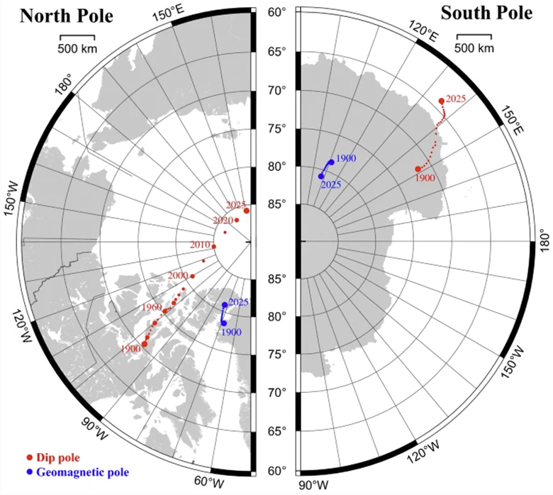
Figure 1: Motion of Magnetic Pole and Dip since 1900. The geomagnetic pole is theoretical and cannot be located directly, while the magnetic (dip) pole describes the two locations where the planet's magnetic field is vertical to Earth’s surface. The scale indicates the distance on the WGS84 ellipsoid, which is correct along lines of constant longitude and the middle lines of latitude shown. The maps use stereographic projection. The left and right panels use different longitude ranges. Image downloaded from MS Bing.
Locate Point
Using the interactive button (Locate) will move the focus to the current map or grid. Click on the map to pick a point:
- If the map/grid has a projection attached, the ground coordinates are converted to Lat/Long and the Latitude & Longitude fields are updated with these values. They will be displayed using the format defined in the Position format field.
-
If the map/grid does not have a projection assigned/it is not georeferenced, a prompt will be displayed. You have two options:
- Assume geographic units: the Latitude /Longitude fields will auto-update with the coordinates located on the map/grid.
- Return to the main dialog without updating the Latitude /Longitude fields.
IGRF vs DGRF
The IGRF model coefficients are reviewed and adjusted over time. The coefficients sets, for which no further changes are anticipated, are known as the Definitive Geomagnetic Reference Field (DGRF). They should be used when the survey is older than the last year that is a multiple of 5. The IGRF coefficient sets covering the period from the last x5 year to now are a best guess projecting forward in time and are subject to adjustment.
Spherical Harmonic Coefficients in Oasis montaj
The models are defined in the DGRF and IGRF tables, which are found in the ASCII files named dgrf.dat and igrf.dat, located in the Oasis montaj \etc folder. For the DGRF models, the secular coefficients are calculated by interpolation between model years, and the required model date values are determined using these coefficients. For the IGRF models, the model is interpolated to the survey date using the secular variation coefficients in the igrf.dat file.
|
Table |
Description |
|
DGRF / dgrf.dat |
Contains all the definitive coefficients for every five years since 1945, up to the latest year that is a multiple of 5. This file is appended with a single set of the most recent IGRF coefficients, which are subject to change over time. Every five years, the last set (IGRF) is removed, and the latest definitive coefficient set is added. Then, the new most recent IGRF coefficient, covering the time from the last x5 year to now, is appended. |
|
IGRF / igrf.dat |
Contains all the published forward-projected coefficients since 1945. In practice, we should only need the last set of IGRF coefficients. However, we save them for backward compatibility and to reproduce georeference field values previously produced. |
The new coefficients are appended to the DGRF table every five years. For backward compatibility, they are retained in the IGRF table.
The Technical Note "Out-of-Cycle Update of the US/UK World Magnetic Model for 2015-2020" contained information about the development and source data for the World Magnetic Model 2015-2020 Out of Cycle update. The coefficients were needed for surveys conducted between years 2015-2020. When the 2020 DGRF coefficients were released, the Out-of-Cycle coefficients were no longer needed; however, for backward compatibility they are available in the IGRF table.
The latest WMM (World Magnetic Model) coefficients are available for download from
*The GX.NET tools are embedded in the geogxnet.dll file located in the \Geosoft\Desktop Applications\bin folder. To run this GX interactively (outside the menu), first navigate to the bin directory and provide the GX.NET tool in the specified format. See the Run GX topic for more guidance.
See Also:
Got a question? Visit the Seequent forums or Seequent support
Copyright (c) 2025 Bentley Systems, Incorporated. All rights reserved.
Privacy | Terms of Use