Drillhole Datasets
Summary
The Datasets tab of the Drillhole Datasets pane allows you to view the drillhole dataset(s) in the current project. If more than one drillhole dataset is present, they will each appear here as "geodatabase\feature dataset name".
Usage
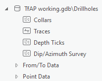
Click on Datasets in the Current Dataset section of the Target tab, to open the Drillhole Datasets pane. The Datasets tab under this pane, presents the contents of all imported drillhole datasets in an order that makes sense for viewing a drillhole project. The spatial location information about the drillholes is presented in this order:
- Collars, Traces, Depth Ticks, and Dip Azimuth Survey data
- From/To Data and Point Data groups.
Selecting a geodatabase\feature dataset will show the Drillhole Dataset Properties in the lower portion of the pane. This includes dataset-level information such as:
- Coordinate system
- Date created
- Last refresh date
Pressing the More button will show a pop up dialog with detailed information about the import source data type and file location.
Add Drillhole Data from the Datasets Pane
From the Datasets pane you can add any feature class, or attribute to the active map or scene:
- Drag and drop any data layer from the pane on to the active map or scene to quickly add to the map and automatically apply symbology.
- Right click on any feature class, or any attribute, in order to quickly add that layer to the active map or scene. There are several options here:
- Use the top "Add To" options (yellow layer icons) in order to use Esri default symbology.
- Use the "Add To New" options to create a new map or scene and add the selected layer.
- Use the Set Default option to set the default symbology style to use anytime this feature class or attribute is added to any map or scene.
- Use the Clear Symbology option to remove the default symbology association.
Expanding a feature class will show the various attributes in each feature class, which can be used for symbology.
Adding data at the attribute level will automatically symbolize the layer based on the selected attribute.
Related Topics
Got a question? Visit Seequent Forums or Seequent Support
