
Interactive Shading
The Interactive Shading tool enables you to interactively adjust the shading parameters (colour saturation, inclination, declination, scale, brightness and contrast) of the active grid. The parameters settings will be retained and saved upon closing the dialog.
Interactive Shading dialog options
|
Shadow grid |
Initially, the grid used to create the shadow image populates this entry. You could, however, select a different coinciding grid, such as a topography grid, to generate the shading from. |
|
Wet look |
Check this box to allow the image colour saturation to vary with the sun angle in conjunction with the grey scale. Leave this option unchecked if a full colour saturation is desired. |
|
Inclination |
Initially, the sun angle inclination (height above the horizon) is set to 45°. You can change the inclination using either the arrow keys or by entering an exact value. The change takes effect immediately on the active grid. You could lock this parameter during interactive shading by clicking on the lock icon located to the right of this field. |
|
Declination |
Initially, the sun angle declination (azimuth angle from north CW ) is set 45°. You can change the declination using either the arrow keys or by entering an exact value. The change takes effect immediately on the active grid. You could lock this parameter during interactive shading by clicking on the lock icon located to the right of this field. |
|
|
Click this button to change the sun angle interactively. The mouse pointer will change to a sun symbol ( As you move the sun cursor on the image, the direction of shading updates in real time: the inclination and declination values are updated automatically in the status bar of the grid/map window. The Inclination and Declination parameters in the dialog will be updated once you click the left mouse button to conclude the interactive shading. The values will be retained upon relaunching the dialog. To exit the interactive mode and undo the changes, click the right mouse button or press the ESC key. See the Application Notes below for more details. |
|
Scale |
The scale factor controls the shading intensity. This parameter is entirely dependent on the grid data distribution and can vary by many orders of magnitude. The default scaling factor yields a perceptually balanced amount of shading. The default scaling factor equation is provided in the Application Notes below. |
|
Brightness
|
Set the brightness level for the shaded grid. The normal brightness is defined at 100%. |
|
Contrast
|
Set the contrast level for the shaded grid. The normal contrast is defined at 50% . |

Application Notes
Interactive Shading
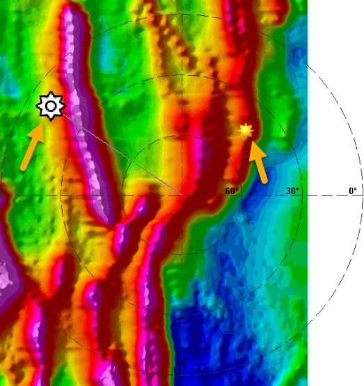
When you click the Interactive Shading button, an overlay, as illustrated in the image below, is displayed and centered on the view. This serves as a guide, providing you with additional information:
-
Two lines intersecting at the center of the view, which represents the rotation point.
-
Three circles that represent the inclination of 0, 30, and 60 degrees. (The inclination of 90 degrees is at the central focal point.)
-
The sun location, represented by the yellow sun symbol, at the existing Inclination and Declination location.
-
Moving the mouse cursor will show the interactive sun (
 ) at the new location with a line extending to the center of the view (the rotation point). The sun moves with the cursor, and the image updates. The current inclination and declination values are updated in the status bar (lower-left corner) as long as the cursor is within the view of the image.
Shading and Scaling
The scale determines how the shading tool interprets the values in your grid. For example, if you use a large scale, you will exaggerate the vertical appearance of your grid and see deep valleys. If you use a very low scale, you will flatten the grid and see very smooth hills.
The stronger the data variation, the shorter the shadows and the faster the progression from dark to light. In addition, the higher the illumination inclination from the horizon, the shorter the progression from dark to light. To balance the shading to accommodate a wide range of data distributions and illumination angles, the shadow distribution is widened for strong data variations and high illumination angles through the use of the scale factor.
The shadow grid is thus calculated using the following equation:
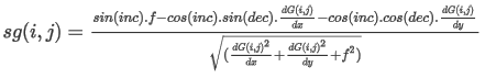
Where:
sg: shadow grid
i,j: ith row & jth column grid indices
inc: illumination inclination
dec: illumination declination
f: 1/scale factor
dG(i,j)/dx: gradient of the i,j grid point in the X direction
dG(i,j)/dy: gradient of the i,j grid point in the Y direction
The default vertical scale factor is set to 2.5 over the mean of the gradient of the input grid:
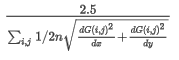
Where:
n: i*j
i,j: grid indices
dG/dx & dG/dy: gradient in X & Y directions
See Also:
Got a question? Visit the Seequent forums or Seequent support
© 2024 Seequent, The Bentley Subsurface Company
Privacy | Terms of Use