
Split Sorties to Original Lines
Use the Split Sorties to Original Lines option (geogxnet.dll(Geosoft.GX.UAVSurvey.SplitToOriginalLines;Run)*) from the UAV Merge Sorties > Merge Planned Sortie menu to break a continuous survey line into individual lines.
Split Sorties to Original Lines dialog options
|
Survey name |
Select from the list the survey project you would like to work with. Multiple surveys can be created within the same GPF. Script Parameter: PLAN_UAV_SURVEY.SURVEY_NAME |
|
Select subarea(s) |
Subareas have unique names. From the drop-down list, select the one whose takeoff location you wish to move. The takeoff location does not need to be inside the subarea. When selected outside the subareas, a white line joins it to the centre of the subarea it belongs to. Script Parameter: PLAN_UAV_SURVEY.SELECTED_SUBAREA |
Application Notes
Generally, a Sortie is flown as a continuous flight, starting and ending at the takeoff point. This data should be split into parallel lines. The travel to/from the takeoff point and the turnarounds should be eliminated in order to be able to merge them with the data of the adjacent sorties.
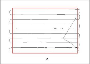
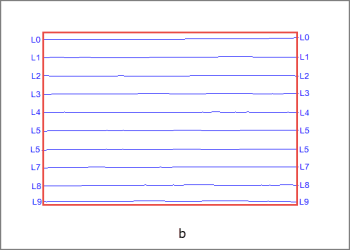
Figure 1: a) The Sortie path as it is flown, b) The Sortie path after splitting
*The GX.NET tools are embedded in the geogxnet.dll file located in the "...\Geosoft\Desktop Applications \bin" folder. If running this GX interactively, bypassing the menu, first change the folder to point to the "bin" directory, then supply the GX.NET tool in the specified format. See the topic Run GX for more details on running a GX.NET interactively.
Got a question? Visit the Seequent forums or Seequent support
© 2024 Seequent, The Bentley Subsurface Company
Privacy | Terms of Use