
Calculate STP Elevation
Use the RPS > Calculate STP Elevation option (geogxnet.dll(Geosoft.GX.Radiometrics.CalculateSTPElevation;Run)*) to apply altimeter correction and calculate the STP equivalent elevation, adjusted for current temperature and pressure conditions. To generate STP-corrected altitude output, the process requires input from either a barometric elevation channel or a pressure channel, along with temperature and radar altimeter data. For further details, refer to the Application Notes.
To rerun the process with previous settings, select the header cell of any channel generated by this operation, then right-click to open the context menu. The last item in the menu is the most recently executed process (GX). Select it to reopen the associated dialog. From there, you can rerun the process using the existing settings, adjust parameters before execution, or simply close the dialog. Learn more about Dynamic Process Links (Makers).
Calculate STP Elevation dialog options
|
Method |
Choose how to correct the height using standard temperature and either barometric elevation or standard pressure:
Refer to the Application Notes for correction equations. Script Parameter: SPECTRO.STP_METHOD [0 - Barometric; 1 - Pressure] |
|
Radar altitude channel |
Select the radar altimeter channel. Script Parameter: SPECTRO.RALTRAW |
|
Temperature channel |
Select the temperature channel and specify its units:
If the channel’s units are already defined in the Units field (right-click the channel header and select Edit to open the Edit Channel dialog) and are set to °C/C or °F/F, the unit selection updates automatically. If you choose units that do not match the channel’s defined units, a validation warning appears. Refer to the Application Notes for conversion details. Script Parameter: SPECTRO.CTEMP |
|
Barometric altitude channel / |
This field is contextual: based on your method selection, either the Barometric altitude channel field or the Pressure channel field will be available. If the pressure channel method is selected, choose the pressure channel and specify its units:
If the channel’s units are already defined in the Units field (right-click the channel header and select Edit to open the Edit Channel dialog) and are set to kPa or mbar, the unit selection updates automatically. If you choose units that do not match the channel’s defined units, a validation warning appears. Refer to the Application Notes for conversion details. Script Parameters: SPECTRO.BALTRAW SPECTRO.PRESSURE |
|
Before converting to equivalent height at standard temperature and pressure (STP), you may need to apply light filtering to radar altimeter data to smooth out abrupt terrain changes.
Script Parameter: SPECTRO.RALTSWAV |
|
|
Output STP altitude channel |
Specify the output channel for the STP-corrected altitude. Default name: Script Parameter: SPECTRO.RALTSTP |
Application Notes
Radiometric analysis techniques require that actual survey conditions be converted to standard atmospheric conditions. This conversion is achieved by adjusting the measured ground clearance to standard temperature and pressure (STP). The resulting STP-equivalent height represents the same mass of air, under STP conditions, between the ground and the aircraft as was present during data acquisition.
STP Correction Equations
The altitude corrected to standard temperature and pressure (STP) conditions can be calculated using one of two methods, depending on the measurement channels available.
Correction for Standard Temperature and Pressure
This method applies when direct measurements of air temperature and barometric pressure are available.
The standard reference conditions are defined as follows:
-
Standard temperature: 273.15 K (0 °C), representing the freezing point of water on the Kelvin scale.
-
Standard pressure: 101.325 kPa (equivalent to 101,325 Pa or 1 atm), corresponding to the average atmospheric pressure at mean sea level.
To correct the measured height to standard temperature and pressure, the STP-equivalent height is calculated using the following equation:

Correction for Standard Temperature and Barometric Elevation
The standard temperature and pressure correction described above assumes the availability of radar altimeter, air temperature, and barometric pressure measurements. However, some systems do not provide direct pressure data. In such cases, barometric altimeter readings can be used.
The STP-equivalent height is calculated as follows:
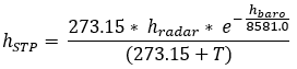
The variables used in the equations above are defined as follows:
-
hradar — Observed height above ground level (metres)
-
hbaro — Barometric height above sea level (metres)
-
hSTP — Equivalent height at STP (metres)
-
T — Air temperature (°C)
-
P — Barometric pressure (kPa)
Unit Conversions
Pressure:
-
1 kPa = 10 mbar
-
1 atm = 101.325 kPa
Temperature:
-
°F = (°C × 1.8) + 32
Processing Workflow
This RPS tool performs the following processing steps:
-
Low-pass filtering of radar altimeter data
-
STP correction of altitude
After processing:
-
If the results are unsatisfactory, rerun the GX and adjust the processing parameters as needed.
*GX.NET tools are embedded in the geogxnet.dll file located in the \Geosoft\Desktop Applications\bin folder. To run this GX interactively (outside the menu), navigate to the bin directory and specify the GX.NET tool in the required format. See the Run GX topic for more guidance.
References
- [1] G. Erdi-Krausz et al. (2003), Guidelines for Radioelement Mapping Using Gamma Ray Spectrometry Data, IAEA-TECDOC-1363, International Atomic Energy Agency.
https://www-pub.iaea.org/MTCD/Publications/PDF/te_1363_web.pdf - [2] IAEA (1991), Airborne Gamma Ray Spectrometer Surveying, Technical Reports Series No. 323, International Atomic Energy Agency.
https://inis.iaea.org/collection/NCLCollectionStore/_Public/22/072/22072114.pdf
Got a question? Visit the Seequent forums or Seequent support
Copyright (c) 2026 Bentley Systems, Incorporated. All rights reserved.
Privacy | Terms of Use