Installing Target for ArcGIS Pro will add a new ribbon to your ArcGIS Pro application, called "Target".
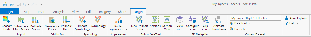
On the Target ribbon you will find nine groups:
Import, Add to Map, Symbology, Appearance, Subsurface Tools, 3D Navigation, Current Dataset, Profile & Help and Upgrade
The following tools and options are available on the Target ribbon:
Geosoft Grids – Import and convert Geosoft grids files into Esri raster datasets
Subsurface Mesh Data - Import subsurface mesh datasets that could contain geological models or other subsurface data
Import Drillhole Data - Import drillhole datasets from a variety of local files or online hosted sources
Geoscience Data – Search for and download geoscience data from a Geoscience Data Portal
Drillhole Data - Add drillhole feature classes and attributes to the active map or scene
Import Symbology - Import previously defined symbology from a layer, csv files, or another geodatabase
Symbology - Create customized drillhole symbologies, set defaults and manage project symbologies
Raster Appearance – Quick appearance options for raster datasets
Quick Hillshade – Apply a multi-directional hillshade raster function to the currently selected raster layer
Equalized Histogram – Apply a histogram equalized color classification commonly used with geophysical rasters
Log-Linear Classified – Apply a log-linear color classification commonly used with geochemical rasters
Import Geosoft Colors – Import the standard Geosoft color tables into your current project styles
New Drillhole Scene - Create a new local scene and add the drillhole collars and traces from the current drillhole dataset
Sections - Create cross sections, modify existing sections and manage the sections in the current drillhole project
Section View - Enable a section view that will allow to slice and intersect data with existing sections in the current project
View From - Change the viewing angle of your current scene
Configure Scene – Configure the current scene settings to be ideal for subsurface viewing
Clip Scene - Automatically set the scene extents
Animate Transitions - Animate changes to the scene viewing angle
Current Dataset Selector - Select the "current" drillhole dataset here, when there are more than one datasets in the project
Refresh Drillhole Imports - Re-import the drillhole data using the original source file location and import settings
Resurvey Drillholes - Recalculate the drillhole traces from survey and collar measurements
Convert Oriented Core Angles - Convert alpha and beta core measurements to absolute dip and dip-direction measurements
|
A link to your Seequent ID profile (shown by your user name) A Help menu which contains the following:
|
|
Access MyGeosoft Support >> for online support and learning resources: Knowledge Base Articles, Guided Learning Path Lessons, Instructional Videos, Technical and Technology Papers, and Best Practices. |
|