
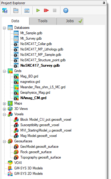
Import from Seequent Evo
Use the Import from Seequent Evo option (geogxnet.dll(Geosoft.GX.Evo.ImportObjects;Run)*) from the Seequent Evo menu  to import geoscience data from Seequent Evo workspaces into your Oasis montaj project. Evo workspaces serve as storage areas where you can publish, view, manage, and share geoscience data across multidisciplinary teams.
You can also access this option from the context menus of Data nodes in the Project Explorer.
This option is unavailable if you are not signed in with your Bentley account or if your subscription does not include Seequent Evo entitlements. Additionally, it will be disabled if you are not connected to a Seequent Evo Instance or you are not assigned to a workspace within the current instance.
To use this feature, ensure that you are signed in and connected to a Seequent Evo instance within your Oasis montaj project. Go to
To update imported data to the latest version, see Reload from Seequent Evo below.
Import from Seequent Evo - dialog options
The dialog displays published geoscience objects in the currently selected workspace in a tree structure. Objects are listed in alphanumeric order and grouped by status. Within each status category, they are further organized by data type.
Unsupported formats will not appear in the list. For more details, refer to Application Notes below.
Select a workspace: |
|
|
Workspace |
The Workspace list displays all workspaces within the currently connected Seequent Evo instance, sorted alphanumerically. Other users within the same instance can share workspaces with you, and any shared workspaces will be added to the list. By default, the first available workspace is selected. Use the drop-down list to select the workspace from which you want to import data. Your selection will be retained after importing, and the workspace will be automatically selected when you reopen the dialog within the same project. Script Parameters: IMPORT_TO_EVO.WORKSPACE_VALUE |
Filter your selection by object name, object data type, creator or last modifier, or a specific published version in Seequent Evo: |
|
|
Filter By: |
You can filter the list by:
Script Parameter: IMPORT_TO_EVO.FILTER_OPTION |
|
Search Objects |
Enter a keyword or search term based on the selected filter. As you type, the list updates dynamically. If items are selected in the tree view, the number of filtered-out objects appears in parentheses and updates in real time as search criteria change. Clearing the filter removes the text and the count in parentheses. Script Parameter: IMPORT_TO_EVO.FILTER_VALUE |
Select the data you wish to import: |
|
|
Click a column header to sort objects within each category in ascending or descending order. Objects are grouped based on their status and reference to the selected workspace. The tree structure includes the following categories and subcategories: |
|
|
New and Changed |
New: Objects under this category have not yet been imported. Changed: These are imported objects that have been modified since the last import. |
|
Unchanged |
Imported objects that remain unchanged since the last import: |
|
Each category will display subcategories for supported data types, such as Grid, Voxel, Geosurface, Drillhole project, provided there is at least one object in the current workspace that can be imported as the respective type and its status matches the category. |
|
|
Version |
The Version field is enabled for each selected object, allowing you to choose from all available published versions. By default, the most recent version is preselected. From the drop-down list, select the instance you want to import. Script Parameter: IMPORT_TO_EVO.SELECTED_OBJECT_VERSION_0_# |
|
Latest Colourmap |
The Latest Colourmap option is available for applicable Grid and Voxel objects and is enabled for each selected object of this type.
See the Application Notes below for additional details. The checked state of objects is retained after importing and reopening the dialog within the same project, and when switching between workspaces.
Script Parameter: IMPORT_TO_EVO.USE_DEFAULT_COLOUR_MAP_# |
|
Selection State: |
Expand/Collapse: Click the chevron icon next to a category or subcategory to expand or collapse the desired node. Checkbox Toggle: The checkbox at the root node level of each category/subcategory acts as a selection toggle that propagates down to the node items and indicates one of the following states: Selection states persist after importing and reopening the dialog within the same project, and also when switching between workspaces. The number of selected objects will always reflect the current selection.
Clearing parameters (Project > Parameters > Clear Parameters) resets settings in both the 'Publish to Seequent Evo' and 'Import from Seequent Evo' dialogs and removes previous object and workspace selections.
Script Parameters: IMPORT_TO_EVO.SELECTED_OBJECT_0, IMPORT_TO_EVO.SELECTED_OBJECT_1,.., IMPORT_TO_EVO.SELECTED_OBJECT_# |
|
[Select All] |
Click this button to select all objects. The total object count will be displayed. If a filter is applied after objects have been selected, Select All applies only to filtered items, leaving previously unselected items outside the filter unchanged.
|
|
[Select None] |
Click this button to deselect all selected objects. If a filter is applied after objects have been selected, Select None applies only to filtered items, leaving previously selected objects outside the filter unchanged.
|
|
Download and open |
Select this option to automatically open newly created datasets, each in its own Viewer window within the project's workspace. The datasets are saved in the current project folder and added to the Data tab in the Project Explorer. Script Parameter: IMPORT_TO_EVO.DOWNLOAD_OPTION [0: Download and open] |
|
Download only |
Select this option to save newly created datasets in the current project folder and add them to the Data tab in the Project Explorer, without opening them in the project's workspace. Script Parameter: IMPORT_TO_EVO.DOWNLOAD_OPTION [1: Download only] |
|
[Drillhole Preferences] |
Available when the selected workspace includes published Downhole Collection objects. When importing downhole collections from Evo, an automatic resurvey is conducted based on predefined drillhole preferences. This resurvey calculates drillhole trace locations (XYZ coordinates) and geometries/shapes using (XYZ) collar locations and survey table measurements (dip, depth, azimuth), if available. Click this button to open the Drillhole Preferences dialog, where you can view and customize import-related settings before initiating the import.
Refer to the Application Notes below for further details on imported downhole data. |
|
[Import] |
You can select one or multiple objects for import. After making your selections, click Import to close this dialog and initiate the download and import process. If a filter is active and some selected objects are hidden due to filtering, a confirmation prompt will appear, asking whether you want to import all selected objects, including those filtered out. To exclude them, clear the filter. The download and import process runs in the background, allowing you to continue working while large objects are retrieved from Seequent Evo. Multiple instances can run concurrently for different objects. Closing the Project During Import If you close the project or exit Oasis montaj while a background process is running, a confirmation prompt will appear. Proceeding with this action may result in only a partially imported dataset or datasets. |
 None of the objects are selected: Deselecting a parent node deselects all child objects.
 All the objects are selected: Selecting a parent node selects all child objects.
 Some but not all of the objects are selected: Selecting at least one child object results in a "partial selection" for the parent node.
Application Notes
*The GX.NET tools are embedded in the geogxnet.dll file located in the \Geosoft\Desktop Applications\bin folder. To run this GX interactively (outside the menu), first navigate to the bin directory and provide the GX.NET tool in the specified format. See the Run GX topic for more guidance.
Import Process
Monitoring Progress in Project Explorer:
- You can track import progress while working on other tasks. The status (e.g., processing, completed, failed, cancelled) and the number of jobs being processed are visually indicated in the Jobs tab.
- New entries for downloaded and translated objects appear in the Jobs tab, under a new node in the tree, marked with the Seequent Evo icon.
- Failures or warnings are signaled with a notification icon
on the job's node. Click the icon to view the captured error or warning. For individual entries/tasks, additional details may be available, indicated by an exclamation icon
. Click the flagged entry's icon for more information.
Refer to the Jobs section in this topic for more details on monitoring progress and reporting results.
Existing Data
If any imported datasets already exist in the current project, an overwrite confirmation prompt will appear:
Clicking [No] preserves the existing datasets while still importing the new ones.
Clicking [Yes] updates existing datasets (voxels, grids, geosurfaces, etc.).
Imported Data
Successfully imported datasets are stored in the current project folder and automatically added to the Data tab in the Project Explorer. Their icons will display a modified version, featuring the Seequent Evo symbol, indicating successful import from Seequent Evo.
Opening Imported Datasets
If the Download and open option is enabled in the import dialog, datasets will open automatically in the current project workspace. Their icons, displaying the Evo symbol, will be visible in window headers when the imported datasets are opened in the current project. However, they will not appear in the Map Manager and 3D Manager panes.
Evo References Across Projects
Evo references are not transferred or shared between projects. Imported objects added to another project will be "unlinked" from Evo, and these datasets will not display the Seequent Evo icons. However, if the entire project directory is shared, Evo references are also shared, and the imported Evo objects will preserve their Evo links.
Removing Imported Objects
When you remove imported objects from the current project using the Remove from Project or Remove All... context menu options, their Evo references are lost. Re-adding them to the project will not restore their link to Seequent Evo, as indicated by the absence of the Evo symbol on their icons.
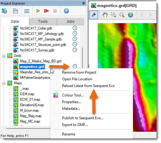
Reload from Seequent Evo
When a new version of an imported object is released in Seequent Evo, its counterpart in the Project Explorer is marked as out-of-date with a blue status indicator  next to it. Additionally, the context menu for the affected dataset will include a new option: Reload Latest from Seequent Evo.
If the dataset is deleted or moved from the project folder, it will appear greyed out and flagged with a warning icon![]() . Use the Find option in the context menu to locate the missing file via the browse dialog. (See Missing Data Files for more details.)
Once a missing dataset is manually located, the blue "reload" status indicator will reappear.
. Use the Find option in the context menu to locate the missing file via the browse dialog. (See Missing Data Files for more details.)
Once a missing dataset is manually located, the blue "reload" status indicator will reappear.
To update the dataset, select it and right-click on the new option. An update confirmation prompt, Import Geoscience Objects, will appear:
-
Selecting Cancel retains the existing dataset, keeping the status indicator visible.
-
Selecting OK imports the latest from Seequent Evo, including the most current colourmap version for grid and voxel types, and updates the dataset. Once the update is complete, the status indicator and the new context menu option will no longer be available.
Unlink from Seequent Evo
If a dataset's counterpart in Seequent Evo is no longer available (e.g., the geoscience object has been recycled, the workspace has been deleted, or you no longer have access to it), a red status indicator  will appear next to the dataset in the Data tab, and a new context menu option, Unlink from Seequent Evo, will be available.
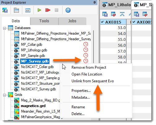
Select this option to remove the Evo reference from the flagged dataset. Once unlinked:
-
The dataset will no longer display the Seequent Evo icon.
-
The red status indicator and context menu option will be removed.
Imported Data
Supported Data Types
Data published to Seequent Evo is stored in
Geoscience Objectformat, which can be shared between Oasis montaj and other Seequent desktop and cloud applications. The object types that can currently be imported into Oasis montaj are regular 2D grids, regular 3D grids, tensor 3D grids, triangle meshes, geological models with meshes, and downhole collections.Regular 2D Grids and 3D Grids
Regular 2D Grids: These types are imported as Geosoft grids:
Horizontal plans are translated into Oasis montaj plan grids.
Planar sections are translated into Oasis montaj section grids.
Regular 2D grids originating from raster data (grid) formats will be imported as Geosoft numeric grids.
Regular 2D grids originating from raster image formats will be imported as Geosoft COLOR grids.
Regular 3D Grids: These types are imported as Geosoft numeric or thematic voxels.
The vector voxel type is not supported.
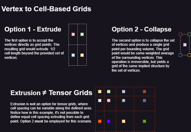
Grids can be defined by cells or vertices. When importing vertex-based 2D/3D regular grids, a conversion to cell-based regular grids will take place. The grid size is extended by one along each axis, and the vertex data is imported as grid points. The resulting grid/voxel will extrude 1/2 cell length along each axis (see "Option 1" in the attached illustration below).
A geoscience object may contain multiple cell or vertex attributes. Importing a multi-attribute 2D grid or 3D grid generates multiple grids/voxels—one for each valid cell/vertex attribute encountered in the object. All generated grids/voxels share the same coordinate system (CS) and CS units when sourced from a single file.
Tensor 3D Grids
Tensor 3D Grids: These types are imported into Oasis montaj as Geosoft numeric voxels with varying cell sizes. Cell-based tensor 3D grids can also be imported into Oasis montaj as thematic (category) voxels.
When importing a vertex-based tensor 3D grid, an average of the cell vertices is calculated to generate a center-cell grid point (see "Option 2" in the attached illustration below).
Conversion Between Vertex-Based and Cell-Based Regular Grids
Certain object types are not supported in Oasis montaj—including 1D geophysical models and point datasets—and will not appear in the Import from Seequent Evo dialog.
Geological Models with Meshes and Simple Triangular Meshes
Geological Model Meshes and Triangle Mesh data types are imported into Oasis montaj as Geosoft geosurfaces. The created geosurface retains the name of the imported geoscience object.
Geosurface Viewer Behaviour:
When a geosurface is opened in the Geosurface Viewer:
A simple triangle mesh is imported as a geosurface with a single open or closed isosurface (surface), retaining the same name as the geosurface.
A geological model with meshes is imported as a geosurface with open and/or closed isosurfaces (surfaces), corresponding to geological features or layers within the model. These surfaces are nested as child nodes under the parent geosurface node
Surface Selection and Display
Closed surfaces (e.g., output volumes) are selected by default in the nodes tree and rendered in the Geosurface Viewer window.
Open surfaces (e.g., contact surfaces) are unselected by default and are not displayed in the Geosurface Viewer window.
Surfaces retain the names of the features within the geological model and are listed alphabetically.
Smoothing control is turned off for all surfaces, and they are displayed with colour fill.
Colour Attributes
- The Colour attribute for imported geological models:
- Closed surfaces: Colours of the corresponding geological features are retained and applied to all closed surfaces within the geosurface.
- Open surfaces: No specific color scheme is applied. Contacts, boundaries, etc., will always default to the fallback colour, which is pink.
- The Colour attribute for imported triangular meshes:
- Open and closed surfaces: A single (flat) colour is supported for both.
- Colour assignment for triangular meshes (e.g., topography) is limited to one colour, with pink as the fallback option.
Statistical and Geospatial Information
The geometry and statistics (e.g., area, volume, number of triangles and vertices) of all surfaces are preserved.
The geospatial and coordinate system information of the imported geological model is retained in the created geosurface.
Downhole Collections
A Downhole Collection object is imported into Oasis montaj as a set of Geosoft databases, all linked to a common, newly created drillhole project. The constituent databases are prefixed with the name of the imported downhole collection object.
If you are licensed for the Drillhole Plotting extension, you can:
Open and close the drillhole project using the Open Project and Close Project options (under the DH-Data menu).
Utilize the imported data to fully explore the extension's tools.
For more information, refer to Overview of Drillhole Plotting Capabilities.
Spatial References and Rendering
Imported datasets retain their coordinate system (CS) and are rendered in Oasis montaj with the same CS and CS units as their published counterparts. Additionally, the following attributes are preserved:
-
Spatial extents (X, Y, Z)
-
Origin and orientation
-
Rendering properties
Rotation
All rotated grids and voxels imported from Seequent Evo into Oasis montaj remain spatially coincident and structurally identical to their originally published counterparts.
-
Voxel cell statistics are identical.
-
Voxel cell sizes along XYZ are identical.
-
Voxel clipping extents are identical.
-
Voxels displayed in the same 3D view reside in the same 3D space.
-
When default local datum transforms are used in the Coordinate System (CS) of the published voxels, the imported voxels display the same projection method and datum transform details in the 'Modify Coordinate System' dialog.
-
CS units such as USft and meters are identical.
Colour Display
Imported datasets handle colour settings based on the Latest Colourmap option:
-
If checked, the dataset inherits the most recent colour display modifications of the published object.
-
If unchecked, the colour display modifications from the selected colourmap in the Select Colourmap dialog will be applied.
Grids and Numeric Voxels:
-
If the object lacks colourmap information or contains an invalid colour zone definition, a default/standard set of category colours (39 zones) is applied. This set is similar to the default
colour.tblused in Oasis montaj for continuous/observational data.
Thematic (Lithology) Voxels:
-
If no colourmaps are available for an imported thematic voxel, a default category colour palette is applied.
-
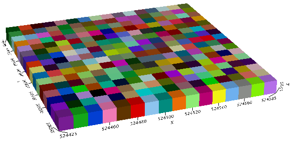
The image below illustrates sequential categories in each voxel cell (starting from the lower-left corner) to demonstrate the palette used for thematic voxels.
Transparency, brightness, clipping, and other visual/display attributes applied to grids or voxels are not expected to be retained upon import.
Colourmaps
When publishing a grid or voxel dataset to Seequent Evo, the Colourmap API:
-
Generates a colourmap based on the dataset's colour display properties.
-
Links the colourmap to the geoscience object representing the dataset.
-
Publishes both the geoscience object and its colourmap to Seequent Evo.
-
Enables seamless integration between Oasis montaj and other Seequent applications, ensuring standardized colour representation across projects and enhancing geophysical data collaboration.
Example of sharing and visualising geophysical data:
In Oasis montaj, a grid dataset is published to Seequent Evo.
The dataset is uploaded as a geoscience object along with its associated colourmap, which stores colour display properties (e.g., colour scheme, distribution).
A geologist imports the geoscience object from Seequent Evo into their Leaprog instance, ensuring:
Colour display settings remain consistent across platforms
No manual adjustments are needed
The data in Leaprog is visualized exactly as it appears in Oasis montaj, using the imported colourmap—eliminating the need to manually recreate colour settings.
Similarly, a geological model can be published from Leapfrog to Seequent Evo.
A colleague then imports the published geoscience object into an Oasis montaj project.
The imported geosurface, which includes surfaces corresponding to the geological features or layers within the geological model, is displayed with the same colour fidelity as in Leapfrog.
This seamless integration ensures accurate colour representation without loss of detail, enabling a geophysicist to leverage the model for tasks such as building a VOXI inversion.
Supported Colourmap Types
When publishing to or importing from Seequent Evo, the following colourmap types are supported:
-
Discrete: For grid or numeric voxel datasets, a discrete colourmap is generated, mapping ranges and colours to dataset values. Each colour corresponds to a specific value range or numeric interval.
- Category: For thematic voxel datasets, a category colourmap is created and linked to the published geoscience object, mirroring its lithology classification codes and colours.
Thematic (lithology) voxels use rock code colours stored in a predefined lithology/rock code CSV file, which includes:
- A “Code” field that matches the lithology classification of the geological data used in generating the voxel.
- A “Colour” field defining numerical values assigned to each code.
When importing into Oasis montaj, the following colourmap type is also supported:
- Continuous: Uses colour gradients stretched across a range of values. When importing a geoscience object with a continuous colourmap (where the colour of a cell is a function of the gradient controls), the colourmap is discretized using linear distribution and mapped to Oasis montaj's internal colourmap representation.
Log and Cache Files
Each import session creates an entry in the Evo log file, which records timestamped processing details. The log file is stored in the log folder within the evo directory, located under the temporary file directory.
Additionally, for each import session, a cache sub-folder is created in the download folder within the evo directory. This sub-folder is assigned a unique eight-character identifier.
Resolving Import Failures Due to Cache File Name Length
If a dataset fails to import because its fully qualified cache file name exceeds the 260-character limit, consider changing the temporary file directory path. To do this, go to Project > Settings > General, then select a shorter Temporary file directory path in the General Settings dialog.
Got a question? Visit the Seequent forums or Seequent support
Copyright (c) 2025 Bentley Systems, Incorporated. All rights reserved.
Privacy | Terms of Use