An Overview of Target for ArcGIS Pro
Installing Target for ArcGIS Pro will add a new ribbon tab to your ArcGIS Pro application, called "Target".
The tools and options available on the Target tab are described below.
With the free version, the licensed tools will be disabled (grayed out) and an Upgrade button will be available. See Licensing Target for ArcGIS Pro for more details.
Some buttons and tools are also grayed out until drillhole data has been imported. If you do not see the Upgrade button, but some buttons are still disabled, start by importing drillhole data.
Hover the cursor over the image below and click to see a full size image of the Target tab:
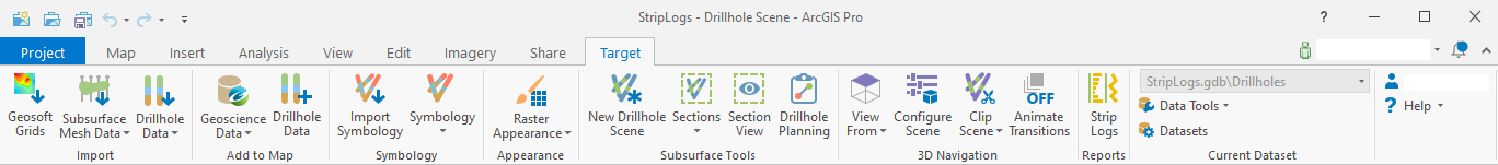
In the Import section:
-
Geosoft Grids – Import and convert Geosoft grids files into Esri raster datasets
-
Subsurface Mesh Data - Import subsurface mesh datasets that could contain geological models or other subsurface data
-
Import Drillhole Data - Import drillhole datasets from a variety of local files or online hosted sources
In the Add to Map section:
-
Geoscience Data – Search for and download geoscience data from a Geoscience Data Portal
-
Drillhole Data - Add drillhole feature classes and attributes to the active map or scene
In the Symbology section:
-
Import Symbology - Import previously defined symbology from a layer, csv files, or another geodatabase
-
Symbology - Create customized drillhole symbologies, set defaults and manage project symbologies
In the Appearance section:
-
Raster Appearance – Quick appearance options for raster datasets
-
Quick Hillshade – Apply a multi-directional hillshade raster function to the currently selected raster layer
-
Equalized Histogram – Apply a histogram equalized color classification commonly used with geophysical rasters
-
Log-Linear Classified – Apply a log-linear color classification commonly used with geochemical rasters
-
Import Geosoft Colors – Import the standard Geosoft color tables into your current project styles
-
In the Subsurface Tools section:
-
New Drillhole Scene - Create a new local scene and add the drillhole collars and traces from the current drillhole dataset
-
Sections - Create cross sections, modify existing sections and manage the sections in the current drillhole project
-
Section View - Enable a section view that will allow to slice and intersect data with existing sections in the current project
-
Drillhole Planning - Create new proposed drillholes on maps or scenes by defining collar and target locations or by specifying collar and trace parameters
In the 3D Navigation section:
-
View From - Change the viewing angle of your current scene
-
Configure Scene – Configure the current scene settings to be ideal for subsurface viewing
-
Clip Scene - Automatically set the scene extents
-
Animate Transitions - Animate changes to the scene viewing angle
In the Reports section:
-
Strip Logs - Create graphical drill logs as detailed single drillhole summary reports.
In the Current Dataset section:
-
Current Dataset Selector - Select the "current" drillhole dataset here, when there are more than one datasets in the project
-
Refresh Drillhole Imports - Re-import the drillhole data using the original source file location and import settings
-
Resurvey Drillholes - Recalculate the drillhole traces from survey and collar measurements
-
Convert Oriented Core Angles - Convert alpha and beta core measurements to absolute dip and dip-direction measurements
-
Get Elevations - Extract values from a raster elevation source to the collar feature class of a drillhole dataset
In the Profile & Help section:
|
A link to your Seequent ID profile (shown by your user name) A Help menu which contains the following:
An Upgrade button if no licensed functionality is available; see Licensing Target for ArcGIS Pro for more details. |
Related Topics:
Got a question? Visit Seequent Forums or Seequent Support